Blizzard and high-wind warnings have been issued for eastern Nebraska and western Iowa, with severe weather expected to arrive early on Wednesday, March 19, 2025. The National Weather Service has cautioned the public about hazardous conditions that will likely impact travel throughout the day.
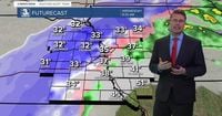
Jesse Castillo, a meteorologist with the Weather Service office in Valley, reported on Tuesday, March 18, that "the higher amounts of snowfall...look to be in northeast Nebraska." The forecast suggests snowfall amounts could range from four to eight inches in the Omaha and Lincoln areas, with specific regions like Tekamah experiencing anywhere from six to twelve inches.
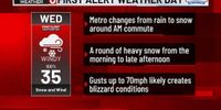
The storm system is projected to track across Nebraska and northern Kansas late on Tuesday before making its way eastward through southern Iowa on Wednesday. Rain is expected to change over to snow between midnight and 3 a.m. on Wednesday, with northeastern Nebraska potentially seeing significant snow accumulation by the morning commute.
"Snow will become heavy around 7 a.m., coinciding with north winds strengthening to 35 to 45 mph, with gusts reaching up to 70 mph," said Katie Gross, another meteorologist from the Weather Service. The dangerous combination of heavy snowfall and strong winds will create blizzard conditions, significantly reducing visibility. Stranded motorists are advised to remain with their vehicles.
Travel is expected to become very difficult to impossible due to widespread blowing snow, particularly during the Wednesday morning and evening commutes. The Weather Service has urged the public to restrict travel to emergencies only and to pack a winter survival kit if traveling is necessary.
Road conditions may deteriorate rapidly as the storm moves in, and visibility could drop below a quarter-mile during periods of heavy snowfall. With the potential accumulation of wet, heavy snow, power lines may be at risk due to the weight of the snow on tree branches, possibly leading to sporadic power outages.
In the Omaha area, all Parks and Recreation community centers are set to close on Wednesday, March 19, except for designated locations like the Hanscom Indoor Tennis Center and the Common Ground Recreation & Aquatic Center. Additionally, Wasteline announced it would suspend trash collection efforts for the day, resuming on Thursday, March 20. Metro Transit services will transition to Snow Route Option B for eleven routes starting at 8 a.m. on Wednesday, while other routes shift to Snow Route Option A.
In light of these forecasts, numerous schools in the Omaha area have announced closures for Wednesday. Schools including Lincoln Public Schools, Bellevue Public Schools, and Omaha Catholic Schools will suspend classes. Several districts are acknowledging that their students are on spring break this week, adding another layer of operational changes.
As temperatures are forecasted to climb into the 50s following the storm, officials are looking towards the potential for rapid snowmelt thereafter. "That's kind of a good thing about these March storms; the snow that does fall doesn't stick around for too long," Gross noted.
As residents brace for the weather, Gross highlighted that the majority of the severe impacts should unfold during the morning commute. The National Weather Service emphasizes that wind gusts will be most intense between 8 a.m. and noon on Wednesday, compelling many to reconsider travel plans.
The tumultuous shift from pleasant, sunny weather to blizzard conditions showcases the unpredictability of spring weather in the Midwest. Early week temperatures reaching low 80s will contrast sharply with the predicted mid-30s by Wednesday afternoon, underscoring how quickly conditions can turn.
On the morning of Wednesday, March 19, residents should anticipate the first snowfall around 7 a.m. as the blizzard warning takes effect. Areas north of Omaha may see minor accumulations compared to other locales, with populated areas like the Omaha metro facing the brunt of the snow's severity.
The inclement weather will linger into the afternoon, tapering off by 4 p.m., but winds are expected to persist, creating a persistent chill through Wednesday night. By the time the storm subsides, some areas may experience road closure due to the winter weather advisory impacting not just commuters, but local businesses preparing for a lengthy cleanup.
As a result of these developments, residents are encouraged to stay updated through local news outlets and weather apps, preparing for possible interruptions to daily life, including travel advisories and educational disruptions.
Ultimately, thoughtful preparation and adherence to weather advisories will be crucial as the Midwest braces for this late winter storm. The community is reminded to take this weather threat seriously, plan accordingly, and stay safe.