A strong storm is set to hit at least 16 states across the U.S. this week, bringing up to 35 inches of snowfall, strong winds, and hazardous travel conditions, as warned by the National Weather Service (NWS). From Tuesday, March 18, 2025, through Friday, March 21, 2025, this winter weather system is expected to impact millions, leading to deep snow and dangerous road conditions.
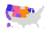
According to NWS reports, winter weather advisories were issued on Tuesday morning for regions across Alaska, California, Idaho, and Colorado, indicating significant snow accumulations could disrupt travel, but may not meet the threshold for full storm warnings. Specifically, winter storm warnings were declared for parts of Montana, Wyoming, and Utah, where heavy snowfall combined with strong winds could lead to extremely difficult travel conditions.
Areas under winter storm watches included parts of Michigan, Wisconsin, Washington, and Oregon, signaling the potential for severe winter conditions developing within 24-48 hours. Meanwhile, blizzard warnings have been announced for parts of South Dakota, Minnesota, Iowa, Nebraska, and Kansas, where the situation could escalate with wind gusts reaching up to 60 miles per hour and whiteout conditions.
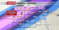
The NWS has specified the severity of the storm, especially highlighting Oregon's Cascades, where up to 35 inches of snow could accumulate from Wednesday afternoon through Friday evening at higher elevations. The NWS also reminded the public to "winterize your vehicle and have a winter emergency driving kit readily available,” to prepare for the inclement weather.
NWS North Platte, Nebraska, noted on their social media account: "Tonight, precipitation switches over from rain to snow. Gusty winds of 40 to 60 mph with falling snow will create areas of blowing snow, with near whiteout to whiteout conditions. The main concern is the reduced visibility overnight."
Meanwhile, NWS Riverton, Wyoming, mentioned on X: "Heaviest snow will occur this morning. Gusty north winds may reduce visibilities and impact travel, especially in the Bighorn Basin this morning and around Buffalo through today. Snow will come to an end tonight."
Travelers are urged to check local advisories, prepare emergency supplies, and heed warnings if traveling through affected areas. Considering the breadth of warnings issued, the current conditions are not anticipated to subside until later this week. Current winter storm warnings and blizzard warnings are expected to remain effective until at least Wednesday, March 19, 2025.
For real-time information and updates, residents are encouraged to visit the National Weather Service website or follow their local NWS offices on social media platforms for the latest guidance and advisories. With conditions worsening, it’s imperative to stay informed and cautious as this significant storm system approaches.