Severe weather is on the horizon for Minnesota, Wisconsin, and Iowa as a potent storm system is set to collide with favorable atmospheric conditions, raising alarms for potential tornadoes, damaging winds, and large hail. As of Monday, April 28, 2025, the National Weather Service (NWS) has issued multiple tornado warnings and a tornado watch that is in effect until 11 p.m. for the Twin Cities metro area.
According to reports from FOX 9, tornado warnings were issued in several counties, including Rice, Steele, Waseca, and Blue Earth, with these warnings set to remain active until 5:45 p.m. on the same day. The NWS confirmed that a tornado had already been reported west of Fairmont, indicating that the storm system is intensifying.
As of 6 p.m., Xcel Energy reported over 4,000 households without power in Minnesota, primarily concentrated in the metro region. The situation is evolving rapidly, with severe thunderstorms expected to develop further as the day progresses.
In a detailed update, meteorologists indicated that while the threat for tornadoes in the Twin Cities appears to be decreasing, the danger remains high in southeastern Minnesota. Joe Nelson, a reporter stationed in the area, noted that severe storms were moving eastward, prompting warnings for communities such as Zumbrota and Kenyon.
At 5:40 p.m., the NWS indicated that the threat of tornadoes was trending down for the Twin Cities, but residents were still urged to remain vigilant as storms could redevelop. The tornado watch remains in effect until late evening, with meteorologists predicting that the most dangerous period for severe weather will occur during the late afternoon and evening.
Warnings continued to roll in as the storm system advanced. A tornado warning was issued for Owatonna and Faribault at 5:45 p.m. Shortly thereafter, another warning was issued for the Waterville area at 5:25 p.m., where Nelson reported from the scene.
By 5:15 p.m., multiple tornado reports were received near Winnebago, with forecasters urging residents to take shelter immediately. The NWS stated, "We have received multiple tornado reports near Winnebago heading northeast. There could be TWO tornadoes down with this warned storm. TAKE SHELTER NOW." This urgent call to action reflected the severity of the situation as the storms continued to develop.
Earlier in the day, at 4:55 p.m., a possible funnel cloud sighting was reported near Princeton, while quarter-sized hail was confirmed around 4:30 p.m. in North St. Peter. The storm system was already showing signs of producing severe weather, with hail reaching Le Sueur County.
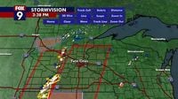
Radar indicated strong rotation near Kimball, prompting a tornado warning for Stearns, Wright, and Meeker counties around 3:45 p.m. This warning included areas such as Clearwater and Watkins, further underscoring the widespread impact of the storm system.
As the storm approached, the NWS updated its forecast discussion, stating that "all hazards" remain possible as the severe storm system moves east. The storms were expected to intensify, producing damaging winds, large hail, and potentially tornadoes as they tracked through western Wisconsin later in the evening.
In anticipation of the severe weather, Minneapolis Public Schools canceled after-school activities, advising caregivers to pick up students immediately. The City of Minneapolis closed its public-facing offices at 2 p.m., with officials warning residents to prepare for severe weather. The city noted, "The National Weather Service predicts the risk of severe storms in Minneapolis to be unusually high – a level 4 of 5 – with tornadoes, large hail, damaging winds, and frequent lightning likely."
The storm system is expected to move into the metro area between 4 p.m. and 8 p.m., creating a window of heightened concern for residents. As the weather continues to develop, residents are urged to stay informed and take necessary precautions.
As of 2:35 p.m., the Storm Prediction Center (SPC) reported a 95% chance of a tornado watch in southeastern Minnesota and the Twin Cities. They warned that peak tornado intensity could reach between 140-170 mph, with wind gusts of 65-80 mph and hail sizes ranging from 2 to 3.5 inches. This forecast highlights the severity of the conditions that residents are facing as the day progresses.
Reed Timmer, a well-known storm chaser, was in Sioux Falls, South Dakota, preparing for the severe weather that was moving into southwestern Minnesota. He indicated that supercells capable of producing strong or violent tornadoes were possible as the storms developed later in the afternoon.
In summary, April 28, 2025, marks a day of significant severe weather threats for Minnesota, Wisconsin, and Iowa. With tornado warnings and watches issued across the region, residents are encouraged to stay alert and take the necessary precautions to ensure their safety. As meteorologists continue to track the storm system, updates will be provided to keep the public informed about the evolving situation.