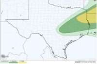
The Southeast region of Texas is bracing for a turbulent start to the week as a cold front approaches, bringing with it a mixture of severe weather risks including thunderstorms, heavy rain, and gusty winds. As of Sunday, March 23, 2025, meteorologists predict that the front will reach the Houston area early Monday morning, leading to potentially severe weather impacts across various counties.
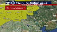
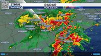
The National Weather Service has issued a Severe Thunderstorm Watch effective until 1 AM on March 24 for multiple counties, including Burleson, Brazos, Madison, and Houston, where damaging winds and large hail are the primary concerns. In particular, the northern segments of Brazos County and the western half of Madison County are under a Severe Thunderstorm Warning until 11:30 PM Sunday night, with forecasts indicating storms capable of producing golf ball-sized hail and wind gusts reaching up to 60 mph. Meteorologist Hayley Adams noted that “Sunday will feature a more active day than what we have seen in the last week,” emphasizing the unstable atmospheric conditions that could fuel severe thunderstorms into the evening and overnight hours.
As Sunday progresses, temperatures in Houston are expected to hover around 65 degrees in the morning, climbing to a high of about 83 by the afternoon. The humidity levels are also expected to rise significantly, with onshore winds from the Gulf contributing to the mugginess. Rain chances are forecasted to increase throughout the day, escalating to 30% by the afternoon and bumping up to 40% after midnight as the front approaches.
Reports indicate that after the slow-moving cold front arrives, it will bring significantly varied weather conditions. Even as the storms may be heaviest in the northern suburbs of Houston and the Brazos Valley, the expected rainfall amounts in Houston itself could remain relatively moderate due to the lack of moisture dynamics and frontal strength. Comparatively light rain is expected in Houston, though residents are urged to remain vigilant as storm conditions could change.
This weather pattern reflects a stark contrast to recent weeks marked by drier conditions. The moisture-rich winds are viewed positively in light of the recent Pauline Road wildfire that ravaged more than 2,400 acres north of Houston, as increased humidity is expected to mitigate future fire risks in the region. Nevertheless, with increased humidity comes the potential for convective storms, which can develop under such atmospheric instability.
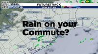
By Monday morning, as the front moves further south, the Houston area is set to experience scattered showers and possible storms as the weather begins to transition back to clearer conditions. The day should start with a 30% chance of rain before 1 PM, after which skies are expected to clear, leading to a warm afternoon with highs around 84 degrees. Winds are predicted to shift from the south to the east post-front, which could offer a slight reprieve from the sticky conditions that have settled over the region.
Looking ahead, the week should remain relatively calm until a mid-week weather system approaches, planned for Thursday, March 27, and Friday, March 28. Forecasts suggest that this system could bring renewed chances for rain and thunderstorms. Residents are encouraged to stay updated through local weather resources to prepare for any shifts in conditions. It’s a reminder of the unpredictability of Texas weather, where slight changes can lead to significant shifts in storm patterns.
In conclusion, while the immediate future may present potential hazards from severe weather, the long-term forecast holds promise for warmer temperatures and increased chances of precipitation later in the week. Houston and its surrounding areas will likely need to stay alert as these weather systems move through, impacting both daily routines and the environment.