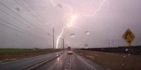
A powerful winter storm is expected to sweep across portions of the Upper Midwest on Wednesday, March 19, 2025, bringing with it the potential for severe thunderstorms and hazardous weather conditions. Cities including Chicago and Indianapolis are on alert for storms capable of producing damaging wind gusts, large hail, and even strong tornadoes. While forecasters anticipate severe weather, they clarify that it will not compare in intensity to the deadly storms that ravaged the Heartland and the South just a week prior, which resulted in at least 43 fatalities from Texas to North Carolina.
The National Weather Service's Storm Prediction Center (SPC) has indicated that over 54 million people from Michigan and Wisconsin down to the Deep South are at risk of severe thunderstorms on Wednesday. Initial warnings were issued following severe thunderstorm activity that had already developed in parts of Nebraska and Iowa, extending concerns across multiple states as the system progresses eastward.
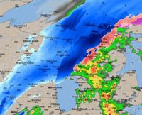
As weather systems converge, meteorologists have placed nearly 2 million individuals in a level 3 out of 5 risk zone just south of Chicago, encompassing central Illinois and parts of western Indiana. This area, which includes cities like Peoria, Decatur, and Champaign, faces the heightened threat of strong tornadoes, classified as EF-2 or higher. Meanwhile, larger metropolitan areas—including Chicago, Indianapolis, and Fort Wayne—are in a level 2 risk of severe weather, yet remain under the shadow of potential tornado activity.
The forecast emphasizes that while thunderstorms are likely to diminish in intensity as they reach Michigan, a window of opportunity for severe weather exists in the early evening, particularly between 8 p.m. and midnight. A detailed assessment notes that the southwestern corner of Michigan, stretching from Benton Harbor to Kalamazoo and Three Rivers, may also experience significant thunderstorm activity. The SPC warns that thunderstorms moving northeast from Illinois and Indiana may retain some of their strength, posing a risk for damaging winds, hail, and isolated tornadoes.
Specifically for Michigan, a level 3 risk is highlighted over the southwest region, while a broader area covering southern Lower Michigan—including Grand Rapids, Ann Arbor, and Detroit—is placed under a level 2 risk. The tornado risk is notably concentrated in a black-hatched region over parts of central Illinois and southern Chicagoland, where strong EF-2 tornadoes or even stronger formations are anticipated.
Severe wind gusts, exceeding 60 mph, are particularly likely in the far southwest area of Lower Michigan, heightening safety concerns as the storms approach. Forecasted data suggests that late evening wind gusts could result in isolated wind damage, further complicating an already precarious weather situation.
The weather forecast for Chicago itself is notably dynamic, offering a mixture of seasonal changes—from severe thunderstorms to the possibility of snow overnight. Wind gusts are expected to persist at over 40 mph, contributing to an atmosphere laden with instability. The SPC has indicated that the vast majority of the Chicago area will experience a 'slight' risk of severe weather, with threats of damaging winds, hail, and the possibility of tornadoes lingering throughout the day.
As nightfall approaches, rain is projected to continue, transitioning into wet snow as the temperature drops—an unusual juxtaposition of spring-like storms and winter's chill. Travel disruptions are anticipated as the weather shifts bring the likelihood of slippery road conditions on Thursday morning.
Consequently, residents across the affected regions are advised to stay alert and prepared, keeping an eye on updates from local weather services. For those in the path of the storms, emergency preparedness and timely awareness can make a important difference.
The combination of these severe weather events places millions at risk, with meteorologists urging communities to stay informed and take precautionary actions. The historic patterns of severe weather in March highlight the need for vigilant attention as forecasters describe an evolving situation that could escalate quickly without warning.
Weather enthusiasts and experts alike will be monitoring developments, as the risk of tornadoes re-asserts itself in the Midwest landscape during this tumultuous weather season. Emergency management practices recommend that everyone affected have a safety plan in place, ensuring readiness for any potential severe storms that could cross their path.
Eyes will be on the sky as the storms roll through, with residents reminded that preparedness is key when facing the unpredictable nature of springtime weather.