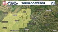
ATLANTA — Severe weather is on the horizon for metro Atlanta and north Georgia today, as a First Alert Weather Day has been declared in anticipation of storms that could bring damaging winds and isolated tornadoes. The National Weather Service has issued a tornado watch for several counties in west Georgia, including Heard, Polk, Carroll, Douglas, Bartow, Floyd, Haralson, Gordon, Paulding, and Chattooga, as well as Cleburne and Randolph counties in Alabama. This watch is in effect until 11 AM on Sunday, April 6, 2025.
The Storm Prediction Center has categorized much of the area under a level 2 "Slight" risk for severe storms. While the intensity of the storms is expected to diminish as they move into north Georgia, isolated strong storms could still produce heavy rain, frequent lightning, and gusty winds.
As of 8:05 AM, the tornado watch was canceled for Catoosa, Murray, Walker, and Whitfield counties in northwest Georgia, indicating a slight easing of the threat in those areas. However, earlier in the morning, severe thunderstorm warnings had been issued for Fannin, Gilmer, Dade, Walker, and Murray counties, reflecting the ongoing storm activity.
According to meteorological updates, storms are already impacting parts of north Georgia this morning, with the main line of storms expected to sweep into west Georgia between 8 and 9 AM. This line is anticipated to bring with it damaging winds, heavy rainfall, and the potential for an isolated tornado.
For residents in metro Atlanta, the storms are projected to arrive between 11 AM and 1 PM. The possibility of isolated severe storms remains a concern during this time. Areas south of the I-85 corridor will experience storm impacts from the early afternoon into the evening.
As the day progresses, the severe weather threat is expected to diminish by around 8 PM. However, the rain is likely to persist into Monday, April 7, 2025, raising concerns about flash flooding. Rainfall totals could reach between 1 to 4 inches within a 24-hour period, increasing the risk of localized street flooding.
Residents are advised to prepare for potentially hazardous conditions and to stay updated on weather alerts. The 11Alive Weather Impact Team has recommended downloading their app for real-time notifications and updates. Users can set up severe weather alerts to stay informed about any changes in the forecast.
In addition to the immediate weather threats, the forecast for the upcoming week indicates a cooling trend, with highs expected to remain in the 60s and lows dipping into the upper 30s to mid-40s. This shift in temperatures follows a period of unstable weather, marking a transition into a cooler spring season.
As communities brace for the storms, officials are urging residents to remain vigilant and to take necessary precautions, especially if traveling. The potential for severe weather underscores the importance of preparedness, particularly in areas prone to flooding and storm damage.
As the day unfolds, residents are encouraged to monitor updates from local news outlets and weather services, ensuring that they are equipped with the latest information regarding the evolving weather conditions.
With the risk of severe weather looming, many are reminded of the unpredictability of spring storms in the region. The combination of warm, moist air and cooler fronts can create the perfect environment for severe weather, making it essential for residents to stay alert and prepared.
As the storms approach, local authorities are also prepared to respond to any emergencies that may arise, with resources allocated to ensure public safety. Emergency services are on standby, ready to assist in the event of severe weather impacts, including potential tornadoes and flooding.
In summary, as the severe weather system moves through Georgia today, residents are advised to stay informed, take precautions, and be prepared for changing conditions. The combination of heavy rain, strong winds, and the potential for isolated tornadoes makes it a critical day for weather awareness in metro Atlanta and surrounding areas.