Weather forecasts across India are indicating a shift as the country transitions from winter to summer, bringing with it a mix of thunderstorms, high temperatures, and moisture-laden rain. Citizen awareness and preparation are critical as the India Meteorological Department (IMD) has issued multiple alerts for severe weather conditions expected over the coming days.
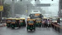
In Delhi, a weather forecast warns of strong winds exceeding 40 km/h on March 20, 2025, combined with significant temperature fluctuations. Temperatures are predicted to range from a low of 16 degrees Celsius to a high of 32 degrees Celsius, with a potential spike to about 36 degrees Celsius early next week. Rain and thunderstorms may begin to affect the metropolitan area soon, prompting residents to stay vigilant.
The situation isn’t any more calming for Uttar Pradesh and Bihar. Following a dry start until March 20, intense thunderstorms, possibly coupled with hailstorms, will arrive from March 21 to 22. Both regions are under caution as weather warnings have been indicated, calling attention to rapidly changing conditions due to the approach of cyclonic systems. Official sources suggest that storms could significantly impact daily life and agricultural practices.
Rainfall alerts have been rolling out for multiple states including Jharkhand and Odisha, set to experience scattered rainfall from March 20 to 22, with wind speeds hitting 30-60 km/h during storms. Residents are advised to heed these weather alerts as hailstorms could also occur in isolated parts of Gangetic West Bengal and Jharkhand, adding further risks in those locales.
West Bengal's weather is anticipated to take a turn starting March 20, with thunderstorms rolling into Gangetic West Bengal. Similar adverse weather is reported, prompting caution as delays and disruptions in daily life play out, stemming from the effects of the impending storms.
The IMD has taken regional forecasts a step further by expressing concerns over southern states as well, particularly with a warning of no immediate heat wave expected in the upcoming 4-5 days. Yet isolated pockets in Gujarat may still experience hot and humid conditions on the 22nd and 23rd of March. Additionally, southern states like Tamil Nadu, Puducherry, Karaikal, and some regions of Karnataka will feel the pressure with humid weather as early as March 20.
Moreover, a weather trough extending from central Odisha toward Vidarbha is expected to reshape atmospheric conditions significantly. Light rain accompanied by thunderstorms will affect Bihar on March 21 and 22 and East Madhya Pradesh and Chhattisgarh from March 20 through March 22, which could exacerbate the state of agriculture and local infrastructure.
Transitioning further west, Madhya Pradesh prepares for a stormy spell with a yellow alert issued by the Meteorological Department due to expected bad weather conditions starting March 19 and lasting for four days. Areas like Singrauli, Sidhi, Jabalpur, and others are on guard with warnings of strong winds up to 50 km/h and thunderstorms. Reports indicate that extensive areas will face light to moderate rain during this period, persisting into March.
Bihar is also gearing up for its own weather change, with a yellow alert in effect for several districts. On March 22, light rain and some drizzle are expected, alongside potential hailstorms in parts of the state. Heavy downpours may occur as systems influence the local weather conditions.
Rajasthan will not be exempt either; predictions of heavy rains over the next 2-4 days could bring down the region’s temperatures significantly. The rains are expected to result from a new western disturbance that is projected to impact the Himalayan regions, assuring farmers and casual observers alike to be prepared for a cooler and wetter environment ahead.
Further off in the northeastern states, the IMD forecasts matching patterns: Arunachal Pradesh should expect light rain followed by more serious conditions on March 21 and 22, with several other states like Assam and Meghalaya slated to follow suit with heavy rains and thunderstorms beginning March 20.
Given these forthcoming weather systems, experts continue to advise precautionary measures for residents amidst the heavy rains and potential crop damage associated with harsh storms. Farmers are specifically recommended to secure their fields and crops, while urban dwellers are encouraged to prepare for disruptions in transportation, power outages, and alter their daily routines accordingly.
The IMD’s assessments highlight how rapidly changing weather can disrupt agricultural cycles and daily living. Staying informed is essential, as citizens are advised to check government advisories and prepare for any potential dangers posed by the elements.
In preparation for adverse weather, the NDRF (National Disaster Response Force) has been placed on alert, reminding citizens of the importance of readiness and vigilance in the face of nature’s unpredictable moods. Government infrastructures are also undergoing pre-storm checks to prevent outages and ensure safety during these turbulent times.
As they brace for change, weather patterns continue to serve as a reminder of the delicate balance of our ecosystem and the volatility of climate change effects. As storms approach, community awareness and infrastructure preparedness will remain paramount in navigating the stormy weather.