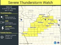
A severe thunderstorm watch is in effect until 10 p.m. on April 17, 2025, across southern Minnesota, including the Twin Cities metro area. The National Weather Service (NWS) has issued this alert, warning residents to prepare for potentially hazardous weather conditions.
Forecasters predict that these storms will be capable of producing sporadic large hail, with stones reaching up to 2 inches in diameter, alongside damaging winds that could gust up to 70 mph. Heavy rainfall and frequent lightning are also expected, raising concerns about flash flooding in some areas.
The HRRR model indicates that a line of storms is currently moving eastward from the Twin Cities into Iowa, with the strongest cells anticipated to develop in far southern Minnesota. This line of thunderstorms is part of a broader weather system affecting much of the region.
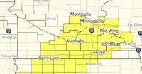
In particular, the Rochester area, located in Olmsted County, is included in the severe thunderstorm watch. This area is on the eastern edge of the watch zone, which encompasses several counties, including Owatonna, Red Wing, Austin, Albert Lea, Mankato, and the Twin Cities.
As the evening progresses, forecasters indicate that strong thunderstorms could develop in south-central Minnesota and move across southeastern Minnesota. The forecast for Rochester suggests that showers and thunderstorms are likely through late tonight, with precipitation totals ranging between three-quarters and an inch of rain. A chance of showers and storms will continue into the morning on Friday, April 18, 2025.
In addition to Rochester, Mower County is also under the severe thunderstorm watch. Residents in this area are advised to remain alert for changing weather conditions, as the potential for severe thunderstorms could lead to large hail, damaging winds, or even a possible tornado.
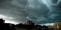
Chief Meteorologist Randy Brock has stated that an active evening of weather is ahead, with a line of thunderstorms developing west of Interstate 35. This line of storms is expected to progress eastward throughout the evening, bringing with it a variety of severe threats.
Even the weaker, non-severe thunderstorms are expected to produce hail ranging from pea to penny size, which could surprise residents unprepared for such conditions. As temperatures begin to cool overnight and into Friday, scattered showers and a thunderstorm or two will remain possible, although severe weather is not expected to continue into the weekend.
Looking ahead, the weather is expected to calm down by Saturday, April 19, 2025, with sunshine and seasonably cool temperatures. However, another round of rain is forecast to return on Easter Sunday, April 20, 2025, mainly from the afternoon into the evening.
As the severe thunderstorm watch remains in effect, residents are encouraged to stay informed through local news outlets and weather services. The NWS advises that those living in the affected areas should prepare for the possibility of severe weather and take necessary precautions.
The severe thunderstorm watch, designated as Watch Number 140, was issued by the National Oceanic and Atmospheric Administration’s Storm Prediction Center at 3:45 PM CDT on April 17, 2025. It is important for residents to remain vigilant and ready to respond should warnings be issued for their specific areas.
In summary, southern Minnesota is bracing for a potentially severe weather event this evening, with a range of threats including large hail, damaging winds, and heavy rainfall. Residents are urged to stay alert and take appropriate safety measures as storms develop.