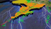
After a gruelling winter filled with relentless snow squalls, powerful winter storms, and a major ice storm to top it all off, Southern Ontario is finally shifting gears into more typical spring and summer-like weather. But with the warmer air comes the return of severe thunderstorms, something Southwestern Ontario has already gotten a small taste of over the past few weeks. Meteorologists are closely tracking the potential for a strong severe weather threat on Tuesday, April 29, 2025.
Model guidance has consistently highlighted the potential for a very active environment capable of supporting tornadoes, large hail, and damaging wind gusts. According to Environment Canada, the strongest severe weather risk will focus across parts of Southwestern Ontario, Central Ontario, and into Eastern Ontario. Other areas across Southern Ontario will still carry a marginal to slight risk, meaning a few severe storms could pop up, but the widespread threat will be lower outside the main zone.
On Tuesday, storm threats include one or two tornadoes, large hail potentially up to the size of toonies or even timbits, widespread damaging wind gusts exceeding 90-100 km/h, and heavy rainfall that could cause localized flooding in some spots. The storm risk will kick off early Tuesday morning as an area of convection moves across the region between 6:00 a.m. and 12:00 p.m. Most of these morning storms should remain non-severe, but a rogue severe cell cannot be ruled out, especially in setups like this.
Where these morning storms track and how quickly they clear out will be important to watch, as leftover clouds or rain could limit how unstable the atmosphere becomes later in the day. By the early afternoon hours, the environment is expected to rapidly become more favorable for severe weather. Areas along the Lake Huron shoreline will likely be the first to feel the effects, with the risk then spreading into parts of Central Ontario.
Geoff Coulson, a warning preparedness meteorologist with Environment Canada, noted that some of the most severe supercell thunderstorms of this year could rip through parts of southern and eastern Ontario on Tuesday afternoon. He indicated that Toronto could potentially see the weather take a dramatic turn late afternoon, with a 70 percent risk of thunderstorms forecasted to start around 5 p.m. and last until 9 p.m.
As the afternoon wears on, a cold front will move through southern and eastern Ontario, kicking off potentially long lines of thunderstorms affecting areas from the Ottawa Valley through the Greater Toronto Area down towards London and Windsor. Coulson explained that one of the most important ingredients for thunderstorm development is a lot of heat and humidity near the surface. Tuesday will bring one of spring’s warmest days with a forecast of 24 °C that feels like 29 °C with the humidex.
Another key ingredient is a lifting mechanism that makes the air rise, which in this case will be the cold front. "If the air starts to rise, it’s going to keep rising," Coulson said. These rising columns of air feed the development of thunderstorms, creating a very unstable atmosphere. Once the cold front moves through Toronto, temperatures are expected to dip and stay around 13 °C for the rest of the week, with a sunny Wednesday and possible showers on Thursday and Friday.
As the storms develop, Environment Canada has issued preliminary guidance about the potential for strong, damaging bursts of winds exceeding 110 km/h, large hail of up to four centimeters in diameter, and tornadoes. Areas east of Georgian Bay could see as many as two rounds of thunderstorms that morning, though these aren't expected to be severe, but will still produce lightning and some locally heavy rain.
As the day progresses, the risk for severe storms will increase significantly. The highest tornado risk will likely occur earlier in the day across Southwestern and Central Ontario when individual storms, known as discrete supercells, can remain separated and feed off the prime environment around them. As the afternoon progresses and storms track further eastward, they are expected to start merging into more of a line, shifting the threat more towards damaging winds and heavy rain rather than tornadoes and large hail.
By late afternoon into early evening, the severe weather risk will push eastward into the Golden Horseshoe and Eastern Ontario. The good news is that the risk should wind down quickly after sunset, which occurs around 8:00 p.m. There could still be some leftover showers or weak storms lingering into the evening, especially across Eastern Ontario, but the threat for damaging weather will rapidly diminish once the sun goes down.
As the day approaches, it’s an opportunity for residents to prepare. Coulson advises people to look around their properties and secure loose objects, as strong winds or tornadoes can turn them into dangerous projectiles. "Some of these storms do produce very strong wind gusts or tornadoes, and these types of winds can pick up loose objects, causing them to be projectiles, making them dangerous to people outside, or causing even more damage when they strike buildings and trees," he cautioned.
People who own lawn furniture and other loose objects on their property should consider securing those items or moving them indoors to prevent them from flying around. Severe thunderstorm watches are typically issued a few hours before storms roll in, so it’s advisable to keep an eye out for any alerts to know when your area could be at risk.
In summary, Tuesday, April 29, 2025, will be a day to be weather-aware in Southern Ontario. With a favorable setup for severe weather unfolding, residents should remain vigilant and prepared for potentially severe thunderstorms, including the risk of tornadoes, large hail, and damaging winds. As always, ensure you have a way to receive alerts if storms develop in your area.


