SEATTLE – After experiencing record warmth on Tuesday, the Seattle area is bracing for a dramatic weather shift as strong to severe thunderstorms are anticipated on Wednesday afternoon and evening.
Temperatures soared above normal on March 25, 2025, reaching highs close to 70 degrees in many parts of western Washington, marking the highest temperatures recorded for this date since records began. Reports indicated that Downtown Seattle could see temperatures spike to 72 degrees, surpassing the previous record of 71 degrees set in 2015.
However, the warmth is expected to be short-lived as weather forecasts from the National Weather Service (NWS) warn of an incoming cold front that will create unstable air conditions across the region. By Wednesday afternoon, conditions will be ideal for thunderstorms to develop, with forecasts indicating a possible onset around 4 p.m.
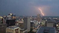
The NWS has categorized the severe weather risk as "marginal," with widespread thunderstorms possible across western Washington, including Seattle. There is also a slight chance of tornadoes in the region, particularly along the Interstate 5 corridor. "There is potential for strong to severe thunderstorms in the Pacific Northwest on Wednesday," an NWS spokesperson noted in their briefing.
As the storm system approaches, the air mass above Washington is expected to remain moist and unstable. Such conditions significantly raise the likelihood of thunderstorms, which can bring heavy rainfall, hail, and damaging winds. Specifically, severe hail (greater than 1 inch in diameter) is projected to occur, with the risk increasing along the I-5 corridor stretching from Everett down to Oregon.
The chance for severe wind gusts accompanying these thunderstorms could also exceed 58 mph in many areas across western Washington. Alongside the substantial wind threat, the NWS highlights a 2-4% chance of isolated tornado activity in parts of the region. This low likelihood is, nonetheless, higher than typical for this time of year in the Pacific Northwest.
The timing of the thunderstorms suggests they will develop between 5 p.m. and midnight on March 26, with the highest intensity predicted just before sunset and tapering off after 9 p.m. During this critical window, motorists are advised to be prepared for difficult driving conditions, potential localized flooding, and falling debris.
While thunderstorms are relatively rare in the Pacific Northwest, where thunder typically contributes to about five to ten days of activity per year, this event is being scrutinized closely. The environment is being set up by a unique combination of high temperatures and atmospheric moisture that can yield dramatic weather phenomena.
Following these thunderstorms, light showers are expected to transition late Wednesday into early Thursday morning as the front moves through the area. This weather shift will bring cooler temperatures that may drop into the mid-50s, contrasting sharply with the warmth felt earlier in the week.
Looking ahead, the National Weather Service has informed that next weekend is projected to be drier, offering a brief relief from the rainy conditions typical of spring.
With these high-stakes weather developments, residents are reminded to stay informed through local news outlets and weather advisories to ensure safety during the tumultuous weather conditions. As always, preparedness is key in unpredictable weather climates, especially with the significant potential for spring-like storm activity on the horizon.
In summary, as Seattle readies for Wednesday's thunderstorms, it's vital for everyone to remain alert and adaptable as the weather transitions from record warmth to severe conditions, marking a pivotal moment in the region's smoothly transitioning into spring.