Temperatures across the Boston area were slightly cooler but remained above the seasonal average yesterday, continuing a trend where March is pacing five degrees warmer than normal. Nights have been noticeably warmer, as freezing temperatures have not been recorded since March 9, and forecasts indicate that this comforting pattern will continue throughout the week.
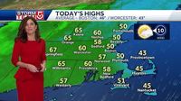
A sliver of high pressure is stationed to the northeast, promising another pleasant day in New England today. Weather observers predict mostly sunny skies, with a weak onshore breeze that will keep coastal regions slightly cooler than their inland counterparts. The morning will commence with brisk temperatures in the upper 40s, and by afternoon, highs are expected to stretch from the low 50s along the coast to the low 60s for areas west of I-495.
As the latest weather system approaches from the west, Globe Weather HQ is keeping an eye on an impending storm that may bring rain, and possibly a mix of snow, to parts of the region late Thursday. This fast-moving system is anticipated to traverse the northern section of the country before slowing down upon its arrival in New England late Thursday evening.
Forecasts indicate that the coastal low will emerge across the Mid-Atlantic on Thursday evening, complementing the main frontal system, which will trigger widespread rain throughout New England. Unlike the deluge experienced earlier this week on Monday, current estimates suggest that precipitation totals will range between a half inch to an inch, primarily occurring from Thursday night into Friday.
Once the storm system moves in, meteorologists expect a change in air mass, starting initially with warm conditions before a flip occurs to a northerly flow. The resulting shift will likely maintain cold enough temperatures in the northern and western regions to generate snow, particularly in higher elevations such as the Berkshires as well as the Green and White Mountains. Early Friday morning lows could dip into the upper 20s to low 30s, enhancing the chances of snow accumulation.
Snow totals are still uncertain, though forecasters speculate that a quick accumulation of one to two inches could fall in the higher terrain, with most lowland areas receiving less than an inch. As for the breakdown of today’s weather across specific regions, Greater Boston can anticipate a mix of sun and clouds along the immediate coast, with inland areas enjoying clearer skies and highs possibly reaching the low 60s, particularly in the Pioneer Valley.
In fact, while the coast will see temperatures in the upper 40s, Central and Western Massachusetts are likely to experience mostly sunny conditions with highs moving into the 60s. The Cape and Islands area will see a sea breeze, resulting in cooler temperatures ranging towards the mid-40s and a mix of sun and clouds. Rhode Island is expected to have a clear day with maximum temperatures pushing into the upper 50s and even some averaging around 60 degrees.
Further north, New Hampshire will bask in mostly sunny weather, with temperatures climbing to the upper 50s and low 60s. Meanwhile, the rest of Northern New England is anticipated to enjoy mostly sunny conditions, with Vermont aiming for temperatures in the 60s and Maine settling into the mid-50s.
Unpacking the weather forecast for the coming days, the transition to rain will commence overnight from Thursday into Friday morning. An expected patch of drizzle may be seen along the coast late tomorrow night, while temperatures will remain steady in the 30s overnight.
As Friday approaches, forecasters are tracking the potential for rainy conditions, especially during the morning commute on March 21, 2025. Between 5 and 8 AM, light rain will likely make its way into the western half of the state, transitioning rather quickly to snow in some spots due to the shifting winds from the north and west.
Midday could also see some snow falling north of the Pike, an outlook that includes parts of the Merrimack Valley and southern New Hampshire. As skies start to clear later Friday night, those living near and north of the Pike might only see patchy coatings, while higher elevations, particularly in the Berkshires and northern Worcester Hills, could measure more significant snowfall exceeding an inch by Friday morning.
Despite the wintery adjustments, the conditions will settle down for the weekend. With expected sunny skies returning, temperatures are predicted to stabilize back into the 50s, and the region should continue to enjoy nice weather into early next week.
For those who relish the changing seasons, this peculiar and somewhat random March warmth provides an unusual opportunity. With blooming flowers and a sunny forecast for the weekend ahead, it remains a reminder of nature's unpredictability.
Daily weather updates continue, and anyone wishing to keep up to date with the Boston-area forecast can receive our daily Globe Weather updates directly to their inbox every weekday morning.