On March 19, 2025, the Kanto-Koshin region experienced unprecedented snowfall due to a developing low-pressure system and cold air flowing through the upper atmosphere. This weather pattern brought heavy snow to mountainous areas, with surprising flurries seen in central Tokyo, creating significant weather warnings throughout the region.
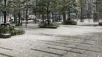
By the time dawn broke, snow had predominantly blanketed the Tama area of Tokyo, with the meteorological authorities issuing a heavy snow warning for parts of Hinohara Village and Okutama Town at 9:28 AM on that day. Reports indicated that by 10 AM, central Tokyo recorded 1 cm of snow as temperatures dropped, causing rains in the early morning to swiftly turn into snow. In Saitama Prefecture, particularly in Chichibu City, observers noted around 6 cm of snow accumulation.
The Japan Meteorological Agency (JMA) advised residents to remain vigilant for potential road hazards, with concerns of snow accumulation spreading to urban areas, including the 23 wards of Tokyo. As the day progressed, it was anticipated that snow would continue to blanket the Kanto plains, posing risks of road surface freezing and transit disruptions.
The snowfall totals leading up to 9 AM on March 19 were substantial, with cumulative snow levels reaching 23 cm in Kusatsu Town, Gunma Prefecture, 21 cm in Ueda City, Nagano, and 18 cm in Karuizawa, also in Nagano. The varying temperatures in the capital city—dipping from 3.4 degrees Celsius at 7 AM to an alarming 0.5 degrees around 10 AM—significantly influenced the snow’s onset and accumulation.
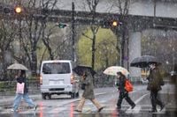
This unusual winter scene, though anticipated due to the low-pressure system's activity, still caught many Tokyo residents off guard. As snow began to accumulate in places typically not used to such weather, there were reports of highways experiencing significant travel disruptions, with portions closed due to heavy snowfall.
Weather forecasters have explained that the temperature fluctuations were mainly caused by a persistent northerly wind associated with the low-pressure system. This wind not only carried cold air but also contributed to heavy precipitation in the form of large raindrops, which, as they fell, dragged down the colder air from above, intensifying the snowfall.
Looking ahead, the forecasting indicates that the weather is set to improve. By around noon on March 19, temperatures in central Tokyo began to rise slightly, transitioning the falling snow to sleet and rain. Most accumulated snow is expected to dissolve under the impending rain, marking the end of this cold snap. However, increased winds could persist, leading to caution against further travel disruptions.
Beyond March 19, the forecast indicates a sharp rise in temperatures beginning on March 21, with expectations of consecutive days exceeding 20 degrees Celsius in major cities including Tokyo, Nagoya, Osaka, and Fukuoka. This warming trend is anticipated to invigorate the bloom of cherry blossoms, with predictions of blooms across regions expected to be reported over the upcoming weekend.
In summary, while the March 19 snow event caused immediate challenges and surprise for many in Japan’s metropolitan hubs, the weather is projected to shift rapidly in favor of warmer temperatures, ushering in the spring season and the beautiful sakura blooms that are cherished throughout the country.