Severe weather has been sweeping across the top of New Zealand's North Island this week, as ex-tropical Cyclone Tam continues to batter the region with heavy rain and strong winds. The storm, which has been reclassified due to its change in structure, remains a significant threat, prompting warnings and preparations from local authorities.
On April 16, 2025, wind speeds reached alarming levels, with gusts hitting up to 140km/h in Northland and 120km/h in Auckland. The storm's impact has already been felt, with over 3500 homes losing power in Northland alone, and residents waking up to darkness on the morning of April 16. Power provider Northpower reported outages affecting areas from Whananaki on the east coast to Dargaville on the west and south to Tinopai.
According to MetService meteorologist John Law, the worst of the weather is expected to hit on Thursday, April 17, with heavy rain and possible thunderstorms forecasted. "It’s been a while since we’ve seen such substantially strong winds, so people need to take extra care," Law advised. The rain radar has already shown heavy rainfall over Whangārei, and the system is moving steadily toward Auckland.
As the storm progresses, MetService has issued severe weather warnings for several regions, including orange heavy rain warnings for Northland and the Coromandel Peninsula. Parts of Gisborne and Bay of Plenty are also under warnings, with up to 180mm of rain expected in Northland. The peak rainfall rates could reach 15-25mm/h on Thursday, raising concerns about surface flooding.
Residents have been urged to prepare for the worst. Auckland Council's general manager of emergency management, Adam Maggs, highlighted the importance of clearing drains and securing items that could be picked up by strong winds. He noted, "We can expect some damage with trees and branches over the next few days, particularly on Thursday. If the public see trees down on public land, go to our council website and report a problem, and then we can deal with that with our arborists."
Motorists are also being cautioned about potential road closures due to the severe weather. The Auckland Harbour Bridge, a critical transport link, could face lane restrictions or even closures at short notice. Maggs advised drivers to check the weather at their destinations and to plan their journeys accordingly, especially as the Easter holiday approaches, which is expected to increase traffic on the roads.
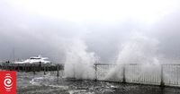
Further complicating matters, the storm is generating large waves along the east coast, with swells expected to reach 6m. Maritime New Zealand has warned that the winds forecast for the top half of the North Island are set to be the strongest since 2017, increasing the risk of damage to trees, structures, and powerlines.
As the storm continues to impact the North Island, the community is coming together to support those affected. Emergency services have been on high alert, with Fire and Emergency New Zealand reporting more than 50 call-outs overnight, most related to trees toppling in the severe wind gusts. Residents are encouraged to stay informed through local news outlets and the MetService website for updates on weather conditions and safety advisories.
Looking ahead, the storm is expected to move southward, arriving in Coromandel, Bay of Plenty, and the north of the South Island by Friday, April 18. As the weather system continues to evolve, authorities remain vigilant, monitoring its path and preparing for any further disruptions.
With the combination of heavy rain, strong winds, and potential flooding, the situation remains serious. Residents are advised to remain cautious, heed warnings, and stay prepared for changing conditions as ex-Cyclone Tam continues to affect the region.