A potent midweek storm has blanketed much of the Alps with significant snowfall, particularly from Wednesday night through Friday. Zermatt stands out as the big winner, potentially racking up as much as 40 to 50 inches by Friday night, April 18, 2025. Val Thorens is also primed for major accumulations, expecting around 25 to 35 inches during the same period. Meanwhile, resorts like Chamonix, Verbier, and Courchevel are flirting with totals in the 20 to 25 inch range.
The storm has already begun to impact travel and local conditions. As of early Thursday morning, April 17, heavy precipitation has aggravated the road and rail situation in Valais. The Simplon Pass road has been closed in both directions due to heavy snowfall, as reported by the TCS traffic service. Furthermore, the Grosse-St.-Bernhard Pass was closed as a precautionary measure the previous evening.
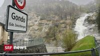
As of Thursday, Simplon Dorf and Gondo are cut off from the rest of Valais, reachable only via Italy. The Valais cantonal police confirmed that several roads have been closed due to snow, including routes between Stalden and Saas-Grund, as well as further to Saas-Almagell. Fallen trees and broken branches have obstructed traffic in various places, according to the Valais Cantonal Command and Control Office.
Rail services have also been severely impacted. The Matterhorn Gotthard Railway announced that the line between Visp and Zermatt will be interrupted due to the storm, with replacement buses running between Visp and Täsch. Currently, there are no travel options to and from Zermatt.
Several municipalities in the canton of Valais are experiencing power outages, although no major damage has been reported thus far. According to MeteoSwiss, the snow line has dropped to 482 meters above sea level at the airport in Sion, reflecting the intensity of the storm.
Meteorologists are expecting between 150 and 250 millimeters of precipitation by Thursday evening. In Zwischbergen, for instance, 103 millimeters of precipitation fell between 7 AM and 2 PM on Wednesday. The amount of fresh snow above 2000 meters is anticipated to reach between 60 and 120 centimeters, with some areas potentially seeing up to 150 centimeters.
The Saas Valley, Simplon region, and Binn Valley remain under the highest warning level for severe weather. The second-highest warning level has been issued for a large part of Valais and neighboring areas, with the risk of avalanches increasing due to the continuous rain and intense snowfall. The Institute for Snow and Avalanche Research (SLF) has warned of numerous large and very large dry avalanches at higher altitudes, as well as medium to large wet snow avalanches at lower elevations.
In light of the severe weather, authorities in Valais have advised residents to avoid travel unless necessary, to stay away from bodies of water, and to be cautious of potential flooding and landslides. The cantonal management body has issued warnings for flooding along the Rhone and its tributaries, where an increase in runoff is expected.
As the storm continues, Zermatt is expected to receive substantial snowfall, with forecasts suggesting an additional 6 to 8 inches overnight from Thursday into Friday, April 18. Val Thorens is also projected to add 3 to 4 inches, ensuring that conditions remain fresh on upper runs.
By Thursday afternoon, Zermatt could have accumulated between 34 to 44 inches of snow, while Val Thorens is expected to rack up around 24 to 30 inches. Chamonix and Verbier are likely to see roughly 18 to 23 inches by the same time, and Courchevel will tally around 17 to 22 inches.
Looking ahead, another weaker system is forecasted to arrive later in the weekend, favoring Zermatt with moderate additional snow while most other resorts are expected to receive only modest amounts. Zermatt's snow totals could continue to climb, with an additional 3 to 6 inches expected from Saturday night into Sunday, April 20.
In summary, the ongoing storm has created significant disruptions in travel and raised concerns about safety in the affected regions. With the snow continuing to fall, ski resorts are bracing for a busy weekend, while local authorities urge caution in light of the severe weather conditions.