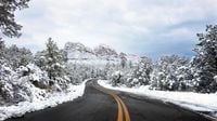
As winter weather returns to the Rockies, parts of Wyoming and Colorado brace for significant snowfall and cold temperatures this weekend. Weather alerts have been issued across both states, with winter storm warnings and advisories in place as the region prepares for a chilly shift.
On Friday, April 18, 2025, much of Wyoming is under the influence of a winter storm, with snow expected in various areas. According to the National Weather Service, winter storm warnings and winter weather advisories are in effect, predicting high temperatures ranging from near 30 to the mid-40s, while overnight lows will dip to near 10 to the low 20s.
In Casper, for instance, a winter storm warning is active until noon, with forecasts predicting up to 2 inches of snow before 10 a.m. and wind gusts reaching as high as 26 mph. The overnight low is expected to be around 16 degrees. Riverton and Jeffrey City are also facing similar conditions, with warnings in place and expected snowfall of up to 2 inches and 3 inches respectively.
Travel conditions may be impacted significantly. In areas like Evanston and Green River, where snow is expected mainly before noon, wind gusts could reach up to 41 mph. The forecast indicates that while some areas may see snow accumulation, warmer pavement temperatures may lead to melting on hard surfaces initially.
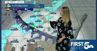
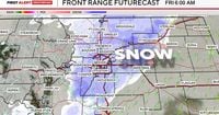
Meanwhile, Colorado is also experiencing a dramatic weather shift. A cold front moving in from Canada is set to bring snow and cold temperatures ahead of the Easter weekend. Friday and Saturday have been designated as First Alert Weather Days, with significant snowfall expected across the Front Range.
The Denver metro area is projected to receive 2 to 5 inches of snow, while foothill areas could see accumulations of 4 to 10 inches. The mountains may experience even greater snowfall, with forecasts indicating 6 to 15 inches from Thursday night through Saturday morning.
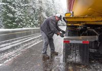
Snow will begin overnight Thursday into Friday, with a second wave expected from Friday afternoon through Saturday morning. Roads in the region are likely to become slick, especially in higher elevations, leading to hazardous travel conditions. The National Weather Service has advised motorists to plan for delays and exercise caution.
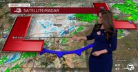
In Colorado Springs, a winter weather advisory is in effect, with temperatures expected to be chilly, reaching a high of only 40 degrees on Friday. Snow showers will be intermittent throughout the day, transitioning from rain to snow as temperatures drop. Pueblo and Canon City will also see similar conditions, with snow expected to move in during the afternoon.
For those planning outdoor activities, the weather is expected to clear up by Easter Sunday, April 20, 2025. Forecasts suggest a pleasant day with highs in the low 60s, making it ideal for outdoor brunches or egg hunts. However, the transition to spring-like weather will be short-lived, as temperatures are predicted to bounce back to the upper 60s to lower 70s at the start of the work week.
In northern Arizona, a winter storm is also making its presence felt. The National Weather Service in Flagstaff has issued a winter weather advisory for elevations above 7,000 feet, where 2 to 8 inches of snow are expected. Gusty winds could exacerbate travel conditions, reducing visibility and creating slick roads, particularly in mountainous areas.
The Kaibab Plateau is anticipated to receive some of the heaviest snowfall, with Jacob Lake forecasted to see between 4 to 6 inches. Travel disruptions are likely as the storm moves in, and motorists are urged to slow down and use caution while navigating the roads.
As these weather systems move across the western United States, the National Weather Service has noted that temperatures could drop as much as 30 degrees below average in some areas. This winter weather pattern is part of a larger system affecting multiple states, including Montana, Wyoming, Colorado, and Utah.
Jacob Lewandowski, a meteorologist with the NWS, commented on the unusual timing of this snowfall. He noted that while the last day for accumulating snow typically falls around May 2, events like this can and do occur in mid-April. “It is not at all unusual to get an event like this at this time of year,” he stated.
As the region braces for this winter weather, forecasters are advising residents to stay updated on conditions and road closures. The storm is expected to begin easing by Sunday, with improved conditions in time for the Easter holiday.
With this winter weather sweeping through the Rockies, residents and travelers alike should prepare for a chilly weekend ahead. Whether it’s staying indoors or gearing up for some snow fun, the return of winter weather is sure to impact plans across the region.