LUBBOCK, Texas (KLBK) — Residents across Texas are bracing for dramatically windy and much cooler weather, with critical fire weather conditions forecasted. A series of weather alerts are currently in place as the region gears up for an active spring season.
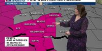
Today's forecast includes wind advisories due to strong northwest winds blowing at 25 to 35 mph, with gusts peaking at 50 mph. These warnings are in effect until 6:00 PM CDT for numerous counties, including Bailey, Briscoe, Castro, and Lubbock, among others. Another advisory also indicates similar conditions in Borden, Dawson, Gaines, and Scurry County in Texas, extending until 3:00 PM today.
In addition to high winds, a Red Flag Warning has been issued, denoting elevated to critical fire weather conditions across multiple regions in Texas, especially where dry conditions persist. This warning will be active until 7:00 PM CDT for several counties, including Childress, Hale, and Hockley. A similar restriction for Lea County in New Mexico also highlights the risks of wildfires.
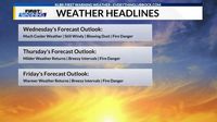
As for Wednesday's weather, the South Plains and Rolling Plains are expected to experience sunny to mostly sunny skies, but blustery conditions and patchy blowing dust will accompany fluctuating temperatures, with highs varying between the lower 50s to mid-60s. Wind speeds will remain consistent, reaching 20 to 40 mph. For tonight, a colder and clearer night is predicted with low temperatures expected to range from the mid-20s to mid-30s.
Moving into Thursday, the forecast remains sunny and breezy with milder temperatures expected. Highs are predicted to be between the middle 60s to lower 70s, with winds shifting from the northwest to the south-southwest at speeds of 15 to 25 mph.
The weather outlook remains dry through the weekend, though fire weather risk extends daily across these regions until Saturday. Friday's highs are anticipated to be between the middle 60s to mid-70s, while temperatures rise on Saturday into the mid-80s before taking another downturn on Sunday with highs varying from the middle 60s to low 70s.
In terms of the broader climate situation, drought conditions continue to pose concerns, particularly as moderate drought (D1) and abnormally dry (D0) statuses are reported across the Southern Plains. The most recent U.S. Drought Monitor update released on March 13 shows the Lubbock metro area holding abnormally dry conditions, with some areas potentially entering drought.
As the spring equinox approaches, officially taking place at 4:01 AM CDT on March 20, many citizens are looking forward to the changing of the seasons and await the warmer temperatures that characterize spring.
This weather information has been carefully compiled from KLBK First Warning Weather Center updates, focusing on helping residents prepare for the varied weather systems affecting their daily lives.