Good morning, Franklin County! Here’s your weather update for today, tomorrow, and the upcoming week:
Today: Friday, March 21 - Conditions: Sunny, with a high near 53°F. Winds: Northwest winds around 13 to 15 mph, with gusts up to 32 mph.
Tomorrow: Saturday, March 22 - Conditions: A chance of showers after 2 PM with partly sunny skies. Highs expected near 58°F, and winds coming from the south at around 5 to 10 mph. Precipitation has a 30% chance of rain.
Currently, temperatures are around 36°F and sunny in Chambersburg, PA, indicating a pleasant, albeit windy day. Forecasters predict that gusty northwest winds will be prominent.
Meanwhile, the National Weather Service has also issued a wind advisory for Carbon and Monroe counties. This advisory is valid today, Friday, March 21, from 5 AM to 2 PM. Northwest winds of 20 to 30 mph with gusts potentially reaching 50 mph are expected. The service warns, "Gusty winds will blow around unsecured objects. Tree limbs could be blown down and a few power outages may result. Winds this strong can make driving difficult, especially for high profile vehicles. Use extra caution. Secure outdoor objects." Reported by the National Weather Service, these statements serve as strong reminders for residents to secure items and drive safely.
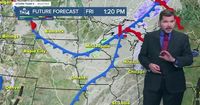
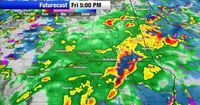
As the day progresses, a cold front should arrive, leading to more cloud cover. Gusty southwest winds are anticipated, boosting temperatures into the mid-50s, with winds possibly gusting up to 35 mph. A few light showers might occur as the cold front moves in this evening, and there's even a chance of snowflakes mixing with the rain.
By Saturday, the weather is forecasted to change favorably. Expect plenty of sunshine throughout the morning, although clouds will roll in later in the day. High temperatures will reach about 40°F, providing a pleasant contrast to the breezy conditions felt today.
Looking ahead to Sunday, March 23, a more dynamic system is projected to bring unpredictable weather. Scattered showers and a wintry mix may start in the morning, transitioning to all rain by the afternoon, with temperatures in the 40s. As the day wraps up, another potential shift back to light snow is on the radar.
In total, rainfall amounts over the past few days have been between 0.2 to 0.4 inches across the region. Today, temperatures will rise into the upper 40s to around 50°F, while gusty winds between 10-20 mph will continue, with gusts between 30 to 40 mph expected.
Temperatures will further drop tonight, falling into the low 30s, creating a clear but chilly end to the day. As we move into the weekend, while Saturday starts off with sunshine and comfortable highs in the mid to upper 50s, be prepared for the clouds and potential showers that are set to arrive.
For the week to come, expect temperatures to remain in the 40s, with fluctuating patterns that could very well mix rain and snow overnight on Sunday.
As always, stay tuned to your local news channels and weather services for live updates and advice on how to navigate these rapidly changing weather conditions.