On Sunday, April 6, 2025, weather forecasts across Europe indicate significant variations, with meteorologists predicting both rain and temperature drops in Italy, while a deep depression named "Olivier" is impacting the Atlantic, particularly affecting Portugal and the Azores.
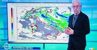
In Italy, meteorologist Paolo Sottocorona, speaking on La7, reported that rain is expected, though only moderate precipitation is anticipated. Areas such as Emilia-Romagna, the Adriatic slopes, and the internal regions of central Italy will see rainfall. Sottocorona clarified that the rain will not be severe, stating, "it's not a strong bad weather event, but the worsening is noticeable, especially with the drop in temperatures." He noted that temperatures could fall by as much as ten degrees.
As for the coming days, Sottocorona explained that the most intense weather phenomena would have passed by Monday, April 7, but the air would still feel colder. On this day, light rain is expected on the Ionian side, major islands, and in the northwest. By Tuesday, April 8, the forecast suggests no significant change in precipitation, with minimum temperatures continuing to decline.
Meanwhile, across the Atlantic, a rare weather event is unfolding in Portugal. The Portuguese Institute of Sea and Atmosphere (IPMA) reported that a deep depression, potentially named "Olivier," is creating unusual conditions for April, with a minimum pressure estimated at around 965 hPa. This is notably low for this time of year, indicating a strong weather system.
In the Azores, the weather is expected to be particularly tumultuous. The forecast predicts very disturbed conditions with cloudy skies and isolated showers on the western islands, while moderate to heavy rain is anticipated elsewhere. Winds from the southwest are expected to reach speeds between 40 and 55 km/h, with gusts possibly exceeding 100 km/h, especially in exposed areas. The sea conditions will be rough, with waves reaching heights of 5 to 6 meters.
On the mainland of Portugal, the day will be marked by cloudy skies, particularly in the Center and South regions. Morning rain will gradually ease in the afternoon, allowing for some sunny spells. In Northern Portugal, the weather will be drier, with occasional showers and greater sunshine. Maximum temperatures are expected to drop slightly, between 1 and 3 degrees Celsius, while winds will generally be weak, blowing from the east at speeds of 10 to 25 km/h. The sea will remain relatively calm, with waves between 1 and 2 meters along the West Coast and the Algarve's South Coast. The water temperature will range from 15 to 16 degrees Celsius, and UV radiation levels are expected to be moderate to high, between 4 and 5.
In Madeira, the weather is expected to be stable on April 6, with pleasant temperatures and light winds from the southwest at speeds of 10 to 20 km/h. The skies will be partly cloudy with frequent sunny intervals, although isolated showers cannot be ruled out. Temperatures in Madeira could rise by 1 to 2 degrees Celsius, and the water temperature will be around 19 degrees Celsius.
Looking ahead to the upcoming week, forecasts indicate a marked increase in temperatures across Portugal between Monday, April 7, and Wednesday, April 9. Locally, temperatures may exceed 30 degrees Celsius, especially on April 8 and 9, which could be the warmest days of the year so far. However, this rise in temperature could be followed by a period of instability, raising concerns about intense thunderstorms and potential flooding if current predictions hold true.
As Easter approaches, which falls on April 20, early indications suggest the possibility of high pressure over Portugal during the period of April 18 to 20, with a precipitation probability lower than 40%. While the outlook points towards drier weather, the uncertainty remains high, and further updates will be necessary as the holiday approaches.
In summary, April 6, 2025, showcases a diverse weather landscape across Europe, with Italy experiencing moderate rain and cooler temperatures, while Portugal grapples with the effects of a deep Atlantic depression. As meteorologists continue to monitor these developments, residents are advised to stay informed about changing weather conditions in their regions.