Veracruz is bracing for a mix of weather conditions as the official start of the Atlantic tropical cyclone season on June 1, 2025, coincides with scattered clouds, light rains, and rising temperatures across the region.
The State Civil Protection Secretariat reported that despite a cloudy start to the day, temperatures are expected to recover to levels similar to those recorded on May 31, 2025, when the minimum temperature was 32 degrees Celsius and the maximum reached 34 degrees Celsius, with a thermal sensation of 38 degrees. This pattern suggests a warm day ahead, though tempered by intermittent rainfall and cloud cover.
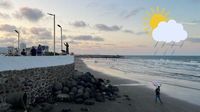
Throughout the morning, Veracruz and its conurbated zones, including Boca del Río and Medellín, experienced predominantly cloudy skies with light rains, particularly in the early hours. The environment is described as cool and humid, with winds blowing from the northeast to the east at speeds ranging from 20 to 35 kilometers per hour, maintaining a high level of humidity that contributes to a muggy sensation throughout the day.
The meteorological situation is influenced by several dynamic systems. Front number 41 is positioned over the northwest of the Gulf of Mexico and the northeast of Mexico, moving slowly southward, mainly over Tamaulipas. This front is linked to a shear line that triggers significant weather changes in the region. Additionally, a trough over the southwest Gulf of Mexico, intensified by upper-level winds, is contributing to cloud development and scattered storms across Veracruz.
Residents in Veracruz should expect a gradual increase in cloudiness after midday, with some rains and thunderstorms especially affecting the mountainous zones. Meanwhile, the Veracruz–Boca del Río conurbated area is forecast to see a slight temperature rise alongside a longer period of sunshine. Coastal areas will continue to experience morning rains and storms, while mountainous regions will see these weather events in the afternoon and evening.
Rainfall accumulation is expected to range between 5 and 20 millimeters in the port of Veracruz, with the heaviest precipitation concentrated in the morning hours. These rains, combined with the prevailing humidity, will heighten the sensation of heat despite the actual temperature readings. The State Civil Protection Secretariat has urged citizens to stay informed about weather changes through official channels and to take necessary precautions due to the presence of scattered storms in various parts of the state.
The onset of the Atlantic tropical cyclone season, which officially began on June 1 and will last until November 30, adds another layer of complexity to Veracruz's weather outlook. This season typically brings an increased risk of storms and cyclones, demanding vigilance from local authorities and residents alike. The early days of June often set the tone for the months ahead, and experts are closely monitoring the evolving weather patterns.
In the mountainous region around Xalapa and other elevated areas, storm clouds are expected to develop and may extend their influence toward the port of Veracruz. This movement of storm systems underscores the interconnected nature of the region's weather, where coastal and inland areas can experience rapidly changing conditions within short periods.
Despite the high temperatures, the intensity of the heat has decreased somewhat compared to previous days, offering a slight respite. However, the combination of heat, humidity, and intermittent storms creates a challenging environment for those living and working outdoors. The winds from the northeast to east not only maintain humidity but also influence the movement of weather systems, potentially bringing more rainfall and storms in the coming days.
Given these conditions, local authorities emphasize the importance of preparedness. The State Civil Protection Secretariat’s call for vigilance reminds citizens that weather forecasts can change quickly, especially during the cyclone season. Staying updated through official weather channels is crucial for safety and planning.
As Veracruz navigates this transitional weather phase, the blend of sun, rain, and tropical storm potential highlights the complexity of the region's climate. The early June weather serves as a prelude to the more active months ahead, where tropical cyclones could pose significant challenges.
Residents and visitors alike should be mindful of the evolving weather conditions, taking appropriate measures to protect themselves and their property. Whether it’s carrying an umbrella during the sporadic showers or heeding warnings about stronger storms, staying informed is the best defense.
In summary, Veracruz faces a day of varied weather on June 1, 2025: warm temperatures with a thermal sensation reaching 38 degrees Celsius, scattered clouds and rains mainly in the morning and mountainous regions, and the official start of the Atlantic tropical cyclone season signaling the potential for more intense weather events in the near future. The combination of meteorological factors demands attention and respect from all who call this vibrant coastal region home.