As temperatures across the UK soar to highs of 25C to 26C for the weekend of May 10-11, 2025, a record-breaking sunny spell is set to be interrupted by severe thunderstorms and heavy rain. This weekend's weather will present a stark contrast, with some regions basking in glorious sunshine while others prepare for thunderous outbursts and heavy downpours.
According to the Environment Agency, the beginning of May 2025 has seen the driest start to spring in 69 years. However, the Met Office has warned that this pleasant weather is under threat. From Saturday night into Sunday morning, there is an increasing chance of rain, showers, and isolated thunderstorms moving northwards across the southwest of the UK. By Monday, May 12, the storm could cover western parts of Great Britain and Northern Ireland.
Dan Harris, the Met Office Deputy Chief Meteorologist, emphasized the potential severity of the upcoming storms. "On Monday itself, we could see some particularly vigorous thunderstorms developing, most likely in Wales and parts of southern England," he said. "Should these thunderstorms develop, especially on Monday, there is potential for 25-35mm of rain to fall in an hour or so, which may lead to some localised surface water flooding. Hail, lightning, and isolated strong wind gusts would be additional hazards."
The dry spell prior to these storms has been a double-edged sword for farmers in England. March 2025 was recorded as the driest since 1961, and April saw only half its normal rainfall. This has forced farmers to start irrigating crops earlier, with reservoir levels notably low across the North East and North West of England. Both regions have experienced their driest start to the year since 1929.
Despite the impending storms, many areas will continue to enjoy warm weather. The Met Office noted that temperatures are expected to build again in sunnier areas, with highs of 26-27°C possible on Sunday and Monday. However, the risk of thunder and rain is expected to spread across more of the UK, including Northern Ireland and western Great Britain, as the weekend progresses.
Forecasts indicate that heavy and potentially thundery showers could arrive on Sunday, particularly affecting the West Country, South Wales, and parts of the West Midlands. Meteorologist Jonathan Vautrey warned of "heavy, short sharp" bursts of rain, which could lead to minor localized flooding due to the heavy nature of these showers. Between 20mm and 30mm of rain could fall within a couple of hours, or as much as 40mm in three hours.
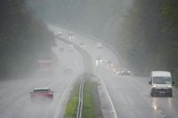
Motorists are advised to exercise caution as thunderstorms could strike with little warning. The Met Office is urging the public to stay vigilant and keep an eye on weather updates throughout the weekend, as conditions could change rapidly, prompting potential severe weather warnings.
As the storms approach, the UK has already witnessed some remarkable weather. The Met Office recorded an average of 228.9 hours of sunshine across April 2025, marking the sunniest April since records began in 1910. This follows the sunniest March for England, which set the stage for the warm start to May. On May 1, the Met Office recorded the hottest day of the year so far, with temperatures reaching 29.3C in London.
Looking ahead, the chance of showers is expected to persist into Tuesday, May 13, across the far south, but higher pressure is likely to dominate, clearing the showers away. Much of the UK will experience another bright, sunny day on Tuesday, with settled conditions covering the vast majority of the country by Wednesday, May 14, and likely remaining through the week.
In summary, while the UK enjoys an unseasonably warm weekend, the forecast warns of significant thunderstorms that could disrupt this pleasant weather. With the potential for heavy rainfall and localized flooding, the public is advised to stay informed and prepared for rapidly changing conditions.