The UK is experiencing a dramatic shift in weather patterns as spring progresses, with record levels of sunshine in March 2025 giving way to forecasts of snow and rain in early May. As the country prepares for a potential cold snap, meteorologists are urging residents to brace for a mix of weather conditions that could impact travel and outdoor plans.
According to a report by Yahoo News, March 2025 was marked by unprecedented sunshine across the UK, leading to a warm start to spring. However, as temperatures rise, weather models indicate that a cold front is approaching. WX Charts has predicted that snow could hit parts of England on Tuesday, May 6, starting at 6am and lasting for approximately 18 hours.
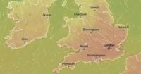
The forecast details a timeline of snowfall, beginning in regions such as Cumbria, Durham, North Yorkshire, South Yorkshire, Northumberland, Derbyshire, and Oxfordshire. By noon, the snow is expected to spread to Lancashire, Greater Manchester, Staffordshire, Derbyshire, Shropshire, and Cumbria, with patches lingering into the evening across Lancashire and the East Riding of Yorkshire. By midnight on Wednesday, May 7, the snow is anticipated to settle in North Yorkshire, West Yorkshire, Durham, and Northumberland before tapering off.
The Met Office's long-range forecast for the period from April 30 to May 9 suggests that while the beginning of May may start off dry and warm, conditions will likely become more unsettled. The forecast states, "Fine, dry and very warm across the majority of the UK at the start of this period with long clear or sunny spells. However, it is expected to be cloudier in the far north with some rain at times." The report also warns of a shift to changeable weather, with potential for heavy and thundery showers as the week progresses.
In a related update from Birmingham Live, the Met Office has confirmed that the UK should prepare for unsettled conditions, with snow and heavy rain expected to impact the country in early May. The WXCharts forecast indicates that the wintry weather could begin as early as midnight on May 6, with Scotland likely to experience the most significant snowfall, extending down to northern England. Rain and snow showers are also predicted across much of southern England.
Temperatures are expected to plummet, with some regions experiencing sub-zero conditions. Inverness is forecasted to dip to a chilly -3°C, although it is expected to rise to 0°C by midday. Meanwhile, southern cities like London will see temperatures starting at 6°C at midnight before dropping to 2°C in the afternoon on May 6.
The Met Office's long-range forecast for May 1 to May 10 indicates that while the month may start dry, this is set to change. The report emphasizes, "Following a widely fine and very warm spell through the week, temperatures are most likely to return back closer to average from the north during Thursday and Friday." It also notes that while a little rain is possible during this transition, most areas will remain largely dry.
As the week progresses, the forecast suggests that conditions will become more variable, with dry and settled periods interspersed with spells of wet weather. This could bring showers or longer spells of rain, which may be heavy and thundery in places. Overall, temperatures are expected to hover around average.
The Daily Mirror has also reported on the upcoming warm spell, predicting that some areas of the UK will experience highs of 27°C on Wednesday, April 30, making it hotter than popular holiday destination Ibiza. While the Met Office does not classify this as an official heatwave, it acknowledges that a "very fine spell of weather" is anticipated.
Matthew Lehnert, the Chief Forecaster at the Met Office, explained that while the April temperature record of 29.4°C, set in Camden Square, London in 1949, is unlikely to be broken, many locations could see local records nudged. The warm spell is driven by air masses from Scandinavia and central Europe, which will be warmed by compression as high pressure builds.
However, as the week transitions into May, the forecast indicates a return to more typical spring weather. The Met Office notes, "Following a widely fine and very warm spell through the week, temperatures are most likely to return back closer to average from the north during Thursday and Friday." This shift will likely bring cooler conditions and potential rain, particularly in northern areas.
As residents across the UK prepare for these upcoming weather changes, the message from forecasters is clear: enjoy the warmth while it lasts, but be ready for the unpredictable nature of British weather. With a mix of sunshine, rain, and even snow on the horizon, it's a reminder that spring often brings both beauty and volatility.
In summary, the UK is poised for a dramatic weather transformation as the month of May approaches. With record sunshine giving way to snow and rain, residents are encouraged to stay informed and prepared for the changing conditions.