The United Kingdom is bracing for a dramatic transition in weather as March heads towards its conclusion, swinging from a mini-heatwave with unprecedented temperatures to a forecast predicting substantial snowfall across various regions. Just as citizens were enjoying the warmest day of the year—with temperatures reaching up to 21°C—a substantial cold front is projected to sweep through, ushering in a wintry mix of snow and rain.
On March 20, reports indicated that the UK would bask in a mini-heatwave, particularly around London and the southern parts of the country. As confirmed by the Met Office, temperatures in the southeast were forecasted to hit 19°C—an unexpected warmth for this time of year. This weather pattern was characterized by clear skies and sunshine after any lingering frost or mist had dissipated, creating a welcoming atmosphere.
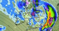
However, this spell of warmer weather is set to take a sharp turn. Following this brief period of respite, forecasts are signaling a significant drop in conditions, with highs quickly descending towards freezing by the end of March. The period spanning from March 22 to 31 looks particularly disruptive, as various weather models indicate that regions primarily across northern England and Scotland will soon experience snow flurries. By March 23, the first waves of snowfall are expected to impact many areas in Scotland, with one weather map hinting at potential flurries beginning early Sunday morning.
According to WX Charts' weather modelling, areas such as the Scottish Highlands and parts of northern England could see accumulated snow, with some reports suggesting accumulations could reach up to four inches as the storm intensifies. The BBC Weather team has further emphasized this unpredictable climate, stating, "Snow coverage data for around the same time shows as much as four inches could be settled on the ground in western parts of the Scottish Highlands," as the temperatures dive below freezing.
As temperatures hit their lows, the nation is set to experience a see-saw pattern of weather conditions. By the early hours of April 1, a storm is expected to move in from the Atlantic, which will facilitate a significant temperature drop across the UK. Insights from advanced weather models show that flurries of snow could arrive, especially targeting the northern parts of England and areas within Scotland, with snow falling at a rate estimated at two inches per hour during peak intensity.
The contrast is stark; after days of basking in the uncharacteristic warmth of March, citizens will suddenly find themselves contending with frost and snow showers. It's a classic hallmark of the UK's transitional spring weather—always unpredictable and often dramatic. The Met Office has advised that the weather will be particularly volatile, highlighting the risks involved: "As we advance into April, the long-range weather forecast models are in better agreement; they show a stronger and longer lasting high pressure signal over the far north-west and far north of Europe through early April at least." This variability suggests the possibility of fluctuating weather patterns continuing well into April.
Moreover, the Met Office warns that the first week of April could feature persistent rain, accompanied by overnight frosts in some regions, with other parts seeing heavy showers. The situation will continue to unfold as warm and snowy spells alternate. As the last days of March roll in, there remains an ongoing risk of weather phenomena reflecting both folksy charm and meteorological severity, with rain and persistent chilly conditions likely to highlight the first week of April.
While the south will enjoy sunny spells and warmth, local weather forecasts caution that northern Scotland and parts of northern England will remain under the remnants of cold Arctic air masses that can spawn both rain and snow, keeping temperatures at a frigid level and raising the risk of icy conditions. In Northern Ireland, temperatures are expected to plummet to around 0°C, signifying a stark departure from the warmth felt earlier in the month.
In conclusion, as we look ahead, it's clear that UK weather continues to embody its mercurial nature. Citizens are urged to remain informed as conditions shift from summery warmth to wintry chills with heavy precipitation threatening to blanket the northern regions. As weather patterns continue to evolve, the anticipation of snowfall offers both excitement and concern, urging everyone to prepare adequately for the chilly weeks to come.