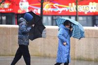
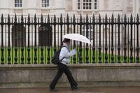
After a week of unseasonably warm and sunny weather, the UK is bracing for a significant change as cooler temperatures and rain are set to sweep across the country. The Met Office has indicated that from Monday, April 14, 2025, a mix of showers, some potentially heavy, will replace the blue skies that have dominated the previous week.
On Sunday, April 13, temperatures in parts of the UK reached highs of 18 to 20 degrees Celsius, with some areas experiencing even warmer conditions. However, as the week progresses, forecasters predict a notable dip in temperatures, with daytime highs dropping to around 12 to 15 degrees Celsius, and nighttime lows potentially falling to freezing in some regions.
According to Met Office Chief Meteorologist Jason Kelly, "A change is on the way this weekend, as we say goodbye to the wall-to-wall sunshine. High pressure sinks southwards and allows low pressure to take hold bringing more cloud, rain and showers, and also lower temperatures." This shift is expected to bring much-needed relief to areas recently impacted by wildfires due to the dry conditions.
In Merseyside, residents can expect periods of heavy showers on Monday afternoon, particularly around 4 PM and again at 7 PM. Rain is forecast to begin around 1 PM, marking a stark contrast to the previous week's sunshine. Temperatures are expected to peak at around 15 degrees Celsius, significantly lower than the highs of 20 degrees experienced just days prior.
Similarly, Northern Ireland is set to experience a similar weather pattern, with temperatures dropping significantly from last week's highs. The Met Office has described the upcoming week as "much more changeable," with a mix of showers, some of which may be heavy, and the possibility of hail and thunder. During the day, temperatures will range from as low as 8 degrees to highs around 12 or 13 degrees Celsius.
Tom Morgan, a meteorologist at the Met Office, explained, "April is, after all, a notoriously showery month, typically one of the most likely for scattered rain. Expect a mix of showers, some of them heavy, with a risk of hail and thunder as well as sunny spells. While they’ll be quite localized, many places will see short spells of rain lasting around an hour."
In Coventry and Warwickshire, the forecast for Monday indicates that while some sunny spells may appear early in the day, cloud cover will increase, and showers are likely, particularly in western counties. Maximum temperatures are anticipated to reach 15 degrees Celsius, with a milder night following.
Moving into Tuesday, April 15, conditions are expected to deteriorate further, with a wetter and cooler day anticipated. Some areas may experience heavy and locally thundery showers, which will continue to characterize the weather throughout the week. The Met Office warns that from Tuesday through Friday, the UK will see a mix of showers and drier spells, with temperatures remaining around average but feeling cooler than in recent days.
Craig Snell, a Met Office spokesperson, noted the potential for thunderstorms and hail, stating, "It is going to be a more changeable week this week compared to what we have been used to for the last two to three weeks. High pressure has gone away now and we’re just going to be firmly under the influence of low pressure as we go through the week ahead."
As the week progresses, the forecast remains unpredictable, with some areas experiencing sunny spells while others will likely see rain. This variability in weather is expected to continue into the Easter weekend, where conditions will be described as a "mixed bag," with some days being wetter than others.
In light of the recent dry spell, the rain is expected to be a welcome development for many, especially gardeners and farmers who have been struggling with the effects of drought conditions. The National Fire Chiefs Council reported that fire and rescue services in England and Wales have responded to 380 wildfires so far this year, more than double the number during the same period in 2022.
Looking ahead to the long-range forecast covering April 17 to April 26, the Met Office warns of continued mixed weather conditions, with low pressure systems bringing heavy rain and potentially disruptive conditions. However, there is a chance that more settled and drier weather could develop as April draws to a close.
Overall, the shift from warm, sunny weather to cooler, wetter conditions serves as a reminder of the unpredictable nature of British springtime weather. As residents prepare for the upcoming changes, the advice remains clear: keep an umbrella handy and enjoy the fleeting moments of sunshine when they appear!