After a summer marked by dramatic swings between heatwaves and heavy rainfall, the UK is on the cusp of another significant weather shift as August approaches. The first half of summer 2025 delivered warmth, sunshine, and three distinct heatwaves, with temperatures peaking at a scorching 35.8C (96.4F) in Faversham, Kent, on July 1. However, recent weeks have seen a notable change, with the jet stream dipping southwards and ushering in low-pressure systems that brought some of the wettest weather of the season, including flash floods in parts of Northern Ireland and eastern England, and even a rare tornado in County Durham.
This unsettled spell culminated in heavy rain and thunderstorms across the UK, prompting several weather warnings. Belfast, for example, was hit by flash floods on the morning of July 21, underscoring the intensity of the recent wet weather. Yet, as the week of July 24-27 unfolds, meteorologists anticipate a "significant change" with high pressure extending from the Azores beginning to influence the weather. This shift is expected to bring drier conditions and more sunshine, especially to southern and western parts of the UK, though westerly winds will keep temperatures moderate, generally ranging between 18-24C (64-75F), with a possible peak of 28C (82F) in southeast England on July 25.
Despite these warmer days, the Met Office clarifies that the heatwave thresholds—defined as three consecutive days exceeding region-specific temperature benchmarks—are unlikely to be met in the immediate term. Forecasts for the end of July predict highs of 27C on Friday, 26C on Saturday, and a cooler 22C on Sunday, falling short of the heatwave criteria. Cooler, changeable westerly winds are expected to dominate early August as well, with rain and showers particularly across eastern England and northern regions.
However, looking further ahead into August, there are signs that the weather could warm up again. Both the Met Office and independent forecasters like WX Charts and Netweather suggest that high pressure may build to the west and southwest of the UK, potentially ushering in more widespread settled and dry weather. This development could pave the way for another spell of very warm or even hot weather, especially in the south and east of the country.
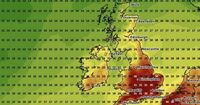
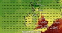
WX Charts’ advanced weather modelling pinpoints August 5 as the start of a possible three-day heatwave, with temperatures forecast to soar to 33C in eight counties including Somerset, Gloucestershire, Oxfordshire, Berkshire, Wiltshire, Buckinghamshire, Hertfordshire, and Hampshire. South East England and East Anglia could see highs of 29-30C, while other areas such as Cheshire, Derbyshire, Nottinghamshire, and Lincolnshire might reach 29C on the same day.
The heatwave is predicted to roll on through August 6 and 7, shifting slightly southwest and bringing 30C-plus temperatures to Hampshire, Wiltshire, Bristol, Bath, and Swindon. By August 7, cities like Birmingham, Cambridge, Northampton, Oxford, Luton, Chelmsford, and parts of Essex could experience highs up to 31C. The Cotswolds, Bath, Bristol, and Wiltshire may also top the charts, while London and Kent are expected to remain in the low 30s. This three-day stretch of 30C-plus temperatures could officially qualify as a heatwave across key parts of the UK.
Such a forecast marks a dramatic turnaround from the patchy, unsettled conditions that have dominated recent weeks, including blustery winds and intermittent rain, particularly in the southeast. The Met Office notes that the highest chance of drier and sunnier weather in early August will be to the east of hills and across southern and eastern regions. Later in the month, if high pressure builds further into the southwest, settled weather may develop there as well, although breezy conditions will persist, especially in northern areas.
While the forecast for August looks promising in terms of warmth, the Met Office cautions that dry, hot weather is far from guaranteed. August traditionally tends to be the wettest summer month in the UK, often recording more rainfall than June or July. Long-range models also indicate that the early days of August will feature spells of rain or showers mixed with drier and brighter intervals.
Met Office meteorologist Aidan McGivern explained on July 22 that warmer air is moving into western parts of the UK, with a ridge of high pressure building by July 27. "By Friday, many places will be drier," he said, highlighting sunshine especially in the east and southeast with temperatures possibly reaching 27C. He added that while showers will linger in Scotland and Northern Ireland, much of England will enjoy sunshine and temperatures in the low to mid-20s.
Looking beyond early August, McGivern remarked that pressure is expected to build more substantially to the west and southwest, bringing widespread settled weather and higher temperatures. "There is a chance of some very warm or hot spells developing later in August if high pressure wins out for a decent stretch of time, especially in the south and east," he noted. However, he also stressed the inherent uncertainty of long-range forecasts, with computer models offering varying scenarios.
Adding to the context, a study published in June 2025 underscores that UK heatwaves are likely to become longer and hotter due to ongoing climate change, with an estimated 50-50 chance of the UK experiencing 40C temperatures again within the next 12 years. This highlights the increasing importance of monitoring and preparing for extreme weather events as the climate continues to evolve.
For now, UK residents can expect a break from the recent wet weather and a gradual return to warmer, sunnier days as August approaches, with the possibility of a notable heatwave early in the month. Yet, as always with British weather, conditions remain subject to change, and the balance between sunshine and showers will continue to shape summer’s final act.