The United Kingdom is bracing for a blistering bank holiday weekend as forecasters predict temperatures will soar to some of the highest August levels in recent memory. Across the nation, millions are expected to flock to beaches, parks, and festivals to soak up the sun, but meteorologists are already warning that the sweltering spell will be short-lived, with the remnants of Hurricane Erin set to sweep in and bring a dramatic change in weather by midweek.
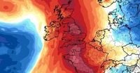
According to WXCharts’ latest weather maps, the heatwave will kick off on bank holiday Monday, August 25, 2025, with temperatures in ten counties—including Sussex, Greater London, and Cambridgeshire—predicted to surpass 30°C. The Mirror reports that the South East will bear the brunt of the heat, with places like Norfolk, Suffolk, Essex, Kent, and Surrey all expected to reach or exceed 31°C. Met Office meteorologist Tom Morgan described the outlook as "very summer-like and really pleasant to warm for most," highlighting that this follows four previous heatwaves that have already marked the summer as one for the record books.
But it’s not just the South that will bask in the sunshine. The East of England is forecast to experience the most intense heat, with Cambridgeshire likely to record the highest readings of the day. Even as far north as County Durham, thermometers will register at least 25°C, while Birmingham will see the mercury rise to around 26°C. The Daily Star adds that a 400-mile-wide "Spanish sizzle"—heat arriving from a scorching 44°C Spain—will ensure the North enjoys a balmy 26°C, outshining even Rabat, Morocco, which is expected to reach only 25°C.
For many, the timing couldn’t be better. The Met Office expects up to 12 hours of sunshine on Monday, delighting Notting Hill Carnival revellers, festival goers, and anyone planning a family barbecue or a last-minute getaway. VisitEngland data suggests the weather could spur up to 10 million additional Brits to hit the roads for spontaneous trips, raising concerns about traffic jams and crowded coastal resorts. Skegness, Scarborough, and Great Yarmouth are all bracing for packed beaches, as reported by the Mirror.
This August bank holiday is shaping up to be one of the hottest since records began in 1965. If the mercury hits 28.2°C, it will become the second warmest August bank holiday ever, surpassed only by the 33.2°C scorcher of 2019. The Met Office, quoted by the Daily Star, said, "Monday is expected to be the warmest day of the weekend, with temperatures peaking around 28°C in the South and Midlands, with widespread sunshine, blue skies, and a summer feel."
Even compared to traditional holiday hotspots, Britain is coming out on top. Tenerife, a favorite destination for British tourists, is only expected to reach 25°C, while Barcelona will top out at 27°C. "Much of Britain will actually outshine the beloved holiday isle of Tenerife today," the Mirror notes, underscoring just how rare these conditions are.
Northern Ireland, meanwhile, is set to enjoy its own sun-splashed day, with the Met Office forecasting temperatures up to 22°C or 23°C, and possibly even 24°C. If that highest mark is reached, it would set a new August bank holiday temperature record for the region, beating the previous high of 23.8°C set in Londonderry in 1983. But as the day wears on, the weather will take a turn. A Met Office spokesperson explained, "At that stage, we start to see cloud thickening and a band of rain starting to move in to the west and most parts by the end of the afternoon. So the first significant rain for some time is actually on its way."
By Tuesday, August 26, the remnants of Hurricane Erin—whose 160mph winds wreaked havoc in Cape Verde, West Africa, resulting in at least nine fatalities—will begin to impact Northern Ireland and the rest of the UK. Rainy conditions are expected to persist, with highs around 20°C and lows dipping to 13°C. The Met Office spokesperson added, "It’s going to be at times fairly blustery, especially as the showers come through over the next few days. But it’s nothing too unusual. The low pressure system is maturing now—so it’s not going to be particularly impactful. But the main, significant, noticeable thing will be the fact it’s more unsettled with rain at times."
Elsewhere in the UK, the sunny spell is expected to subside by Wednesday, August 27, as the after-effects of Hurricane Erin bring thunderstorms, heavy rain, and strong winds. The Mirror and Daily Star both report that the Met Office’s long-range forecast points to low pressure dominating the weather pattern through the end of the week, with dry intervals between showers and frontal rain bands. Winds could be especially strong around coastal areas as these systems move through, but temperatures are expected to remain around average—still feeling pleasant enough during the drier spells.
Met Office chief meteorologist Paul Gundersen summed up the forecast: "High pressure over the UK this weekend and into Monday will help to keep any more persistent rain offshore and will bring a good deal of dry, fine, and settled weather. Cloud amounts are the main variable through the weekend... But temperatures are generally on the rise through the weekend, possibly peaking around 28°C in some parts of southern and central England on Monday." Fellow meteorologist Alex Deakin echoed this optimism, noting, "It is going to get warmer, generally getting sunnier as well, so by the time we get to Monday, I think we will see more blue skies generally."
However, sunseekers are being urged to make the most of the glorious weather while it lasts. By Tuesday, heavy rain and "monster winds" are expected to sweep across the country, displacing the settled conditions and ushering in a more typical late August pattern. As the Met Office put it, "The remnants of ex-Hurricane Erin will see a band of rain, which could be heavy, pushing over the UK, displacing our settled weather and bringing more spells of rain and perhaps strong winds in places by midweek." Temperatures will tumble to the low 20s by Wednesday, signaling the end of the summer’s last great heatwave.
As the nation prepares for a dramatic shift from sun-drenched celebrations to unsettled skies, one thing is certain: this bank holiday will be remembered for both its record-breaking heat and the swift arrival of autumn’s first storms.