The UK is gearing up for a mini heatwave that is expected to last six days, bringing balmy temperatures and sunny skies to a vast majority of the country. According to the Met Office, as many as 92 counties will bask in warmer weather, with 71 counties, including England, Wales, and the Isle of Wight, set to benefit from this pleasant spell.
Starting Sunday, March 30, 2025, temperatures are predicted to reach 18°C in Watford, making it temporarily hotter than Barcelona, which is forecasted to see only 17°C on the same days. The warm weather will continue into the week, peaking at 20°C on Wednesday, April 2, and Thursday, April 3.
The Met Office has indicated that the warm conditions will be a welcome change, especially after a period of unsettled weather. The BBC Weather forecast for Thursday, March 27, noted that many areas would experience windy conditions and heavy rain, particularly in Scotland and Northern Ireland. However, the southern regions are expected to see drier and sunnier conditions.
On Friday, March 28, the weather outlook suggests that rain will clear from the southeast, leaving behind sunny spells and patchy clouds. Scattered showers are likely, particularly in the northern and western parts of the UK, where wintry conditions may affect some northern hills.
As the weekend approaches, Saturday, March 29, is forecasted to start with early sunshine before cloud cover increases. The south will remain mostly dry, while the north braces for wind and rain. Sunday, March 30, will be mostly dry with sunny spells in the east, while the west may see more cloud cover.
By Monday, March 31, the dry weather is expected to continue, with cloudy skies in the west and sunny breaks in the east. This pleasant weather is anticipated to last until the first Saturday of April, April 5, 2025.
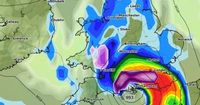
However, the weather is set to take a dramatic turn shortly after. A snowstorm is predicted to sweep across parts of England, Wales, and Northern Ireland, with advanced weather modeling suggesting snow could fall at a staggering rate of around two inches per hour. The storm is expected to make landfall in the early hours of April 8, bringing intense flurries to the southwest of England, southern Wales, and eastern Northern Ireland, including Belfast.
By midday on April 8, the snowfall is likely to focus on southern-central England, with London also expected to be affected. At this point, snow could accumulate at a rate of approximately 5cm per hour. Lighter snow is also anticipated over central Wales and the Pennines in northern England, with the western Highlands in Scotland seeing similar conditions.
Snow coverage maps indicate that by midday on April 8, between 1cm to 2cm of snow could settle on the ground across southern Wales and the southwest of England. While some snow is expected to settle in the southeast, the Pennines, and parts of Scotland, accumulations in these areas are not projected to be as significant.
The Met Office's forecast for the period from April 1 to 10 warns of potential cooler weather ahead. It states, "From the start of April, settled weather is expected to cover much of the UK. Most places are expected to be dry with clear or sunny spells and light winds. Inland areas will see a general day-on-day warming next week. However, it will probably remain slightly cooler near coastal areas, with an additional risk of mist or sea fog affecting parts of the east coast."
Despite this, the BBC's forecast for March 31 to April 6 warns of an Arctic "cold snap" that could take hold, as global weather prediction models struggle to depict a consistent weather pattern. Some models suggest a stronger high-pressure signal could shift over the north-west of Europe, leading to an increased risk of colder air masses moving across the UK.
As the spring season progresses, the weather in Watford and surrounding areas will likely fluctuate significantly. Residents are encouraged to enjoy the sunshine while it lasts, as the unpredictable nature of British weather means that conditions can change rapidly.
In summary, while the UK prepares for a mini heatwave bringing warmer temperatures and sunshine for several days, the forecast also indicates a potential snowstorm that could significantly impact many regions shortly after. This rollercoaster of weather serves as a reminder of the ever-changing climate patterns experienced across the nation.