As the Atlantic hurricane season presses on, two tropical storms—Juliette in the Pacific and Fernand in the Atlantic—have drawn the attention of meteorologists and mariners alike. On Tuesday, August 26, 2025, the U.S. National Hurricane Center reported that both systems were churning over open waters, with neither posing an immediate threat to land. Yet, in a season already marked by the destructive power of Hurricane Erin, the ripple effects of these storms have been felt far beyond their swirling centers.
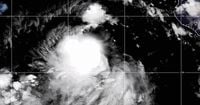
Tropical Storm Juliette, the more powerful of the two, was situated about 515 miles (825 kilometers) west-southwest of the southern tip of Mexico’s Baja California peninsula on Tuesday. Packing maximum sustained winds of 65 mph (100 kph) and moving northwest at 10 mph (16 kph), Juliette was expected to weaken by Wednesday and transform into a remnant low later that day, according to the National Hurricane Center. Forecasters emphasized that Juliette was not expected to threaten land, but its presence still led to rough seas and delays for vessels navigating the busy shipping lanes off the Mexican coast.
Meanwhile, on the other side of the Americas, Tropical Storm Fernand spun in the Atlantic about 595 miles (955 kilometers) south of Newfoundland. With maximum sustained winds of 40 mph (64 kph) and heading northeast at 12 mph (19 kph), Fernand, too, was forecast to remain over open ocean waters and lose strength, potentially becoming a post-tropical cyclone by Wednesday night. As with Juliette, no coastal watches or warnings were in effect for Fernand as of Tuesday.
While neither storm was expected to make landfall, their impacts on maritime operations have been significant. According to the Associated Press, both storms have caused shipping interruptions and created hazardous conditions for seafarers, especially near major shipping routes. Even when storms stay far from shore, their ability to disrupt the flow of goods and delay vessels can ripple through global supply chains. "Both storms showcase the destructive potential of even remote storms on critical shipping lanes and regional maritime safety," noted one meteorological summary.
But the story of this hurricane season is not just about storms far from land. The legacy of Hurricane Erin, which neared the northern Caribbean and the U.S. just last week before dissipating, continued to make itself felt in tragic and powerful ways. Heavy swells generated by Erin’s passage hammered the northern Caribbean, particularly Puerto Rico, where the aftermath has been both dangerous and deadly.
Over the weekend and into Tuesday, a high surf advisory was in effect along Puerto Rico’s north coast. Waves exceeding 10 feet (3 meters) crashed onto beaches and rocks, drawing both thrill-seeking surfers and unsuspecting tourists into perilous situations. On Sunday, August 24, a 31-year-old surfer went missing off Kikita Beach, a popular but notoriously challenging spot on the island’s north shore. His body was discovered on Tuesday, August 26, by local police, bringing a somber close to a desperate search.
Monday brought further heartbreak. The U.S. Coast Guard retrieved the body of a 37-year-old surfer from Chatarra, a break in the north coastal town of Loiza known for its powerful waves and risky conditions. In a separate incident the same day, police found the body of a 40-year-old tourist from New York who had been swept away by a large wave after climbing rocks near the ocean. These tragedies underscored the dangers that linger long after a hurricane has passed, as residual swells and unpredictable surf continue to threaten lives.
The National Hurricane Center and local authorities have repeatedly warned residents and visitors to respect high surf advisories and avoid risky coastal activities during and after major storms. "The cyclone’s nearness to Baja California raised some concern for possible coastal rip currents and swells, but the storm was expected to weaken, improving conditions in the area," reported a summary from the Center. Yet, as recent events in Puerto Rico have shown, even dissipated storms can leave behind hazards that catch people off guard.
Beyond the human toll, the economic effects of these storms are far-reaching. Maritime delays caused by rough seas and altered shipping routes can slow the movement of goods, disrupt schedules, and strain already fragile supply chains. During the height of hurricane season, ports and shipping companies must remain vigilant, adjusting operations to ensure the safety of crews and cargo alike. As one observer noted, "It is not only the bordering regions that suffer economically due to the local shipping and flights being held up, but the entire economy suffers."
Despite the absence of immediate landfall threats from Juliette and Fernand, their presence has served as a reminder of the unpredictable and interconnected nature of global weather systems. Meteorologists continue to monitor both storms closely, tracking their movements and issuing updates to mariners and coastal communities. The U.S. National Hurricane Center remains the primary source for official forecasts, advisories, and warnings, helping to ensure that those in harm’s way have the information they need to stay safe.
For residents of the Caribbean, the U.S. Gulf Coast, and the Atlantic seaboard, hurricane season is a time of heightened awareness and preparation. Even when storms remain distant, their indirect effects—ranging from dangerous surf to economic disruption—can be profound. The events of the past week have highlighted the need for ongoing vigilance, respect for nature’s power, and clear communication between authorities and the public.
As the season moves forward, officials urge everyone to heed warnings, stay informed, and avoid unnecessary risks near the water. The tragic losses in Puerto Rico serve as a stark reminder that even after a storm has passed, its dangers may persist. With Juliette and Fernand still swirling at sea and the memory of Hurricane Erin fresh in mind, the region remains on alert, watching the horizon and hoping for calmer days ahead.