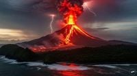
The Barren Island volcano, India’s only active volcano and a geological marvel of South Asia, has erupted twice within a single week in September 2025. Sitting quietly in the remote Andaman Sea, about 140 kilometers east of Port Blair, this uninhabited island has once again captured the attention of scientists, the Indian Navy, and the public alike. While the eruptions were minor and posed no immediate threat to human life or property, they have reignited discussions about the region’s restless tectonic underbelly and the importance of vigilant monitoring.
The first of the recent eruptions occurred on September 13, followed by another on September 20. Sandwiched between these events was a magnitude 4.2 earthquake that struck the Andaman Sea on September 18, just two days before the second eruption. According to officials cited by PTI and The Times of India, both eruptions were minor, but their timing and the sequence of seismic activity have scientists intrigued. The Indian Navy, which was on patrol in the area, managed to capture dramatic video footage of red-hot lava racing down the volcano’s slopes and plumes of thick smoke billowing from the summit. The footage, widely shared on social media and news platforms, added to the spectacle and urgency of the situation.
Barren Island is not just a geographical oddity—it is the only active volcano in all of South Asia. The island itself is roughly circular, measuring about 3.2 kilometers in diameter, and rises nearly 2 kilometers from the sea floor. Its main summit stands between 300 and 354 meters above sea level. The island covers an area of approximately 8.34 square kilometers and is composed largely of volcanic ash and rocks, creating a stark, otherworldly landscape. Despite its inhospitable terrain, the island is home to a few hardy creatures such as feral goats, rodents, bats, and some bird species. However, for safety reasons, human landings are strictly prohibited, and there are no permanent facilities on the island.
The geological setting of Barren Island is as fascinating as its eruptions. The island lies at the active boundary between the Indian and Burmese (Sunda) tectonic plates, a classic subduction zone where the Indian plate slips beneath the overriding plate. This process not only creates the conditions for frequent earthquakes but also provides pathways for magma to rise from deep within the Earth’s mantle. According to O P Mishra, director of the National Centre for Seismology, "Andaman-Nicobar Island is located in the subduction complex consisting of the downgoing Indian plate intruding into the mantle of the overriding Sunda Plate where continuous earthquakes of moderate to strong strengths used to occur besides the micro seismicity in the area." (The Times of India)
The recent eruptions are part of a sporadic pattern that has defined Barren Island’s activity for centuries. Historical records from the Andaman and Nicobar administration indicate that the first documented eruption occurred in 1787. After lying dormant for over 200 years, the volcano dramatically reawakened in 1991. Since then, it has shown intermittent activity, with minor eruptions recorded in 1991, 2005, 2017, 2022, and now, twice in September 2025. Geologists believe that these episodes are closely linked to seismic disturbances in the region. As Mishra explained, the earthquake on September 18 caused "earthquake shaking intensity" within the magma chamber, located 18–20 kilometers below the surface, which made it "apt for a pre-mature magmatic eruption."
The link between seismic activity and volcanic eruptions is well-established in subduction zones like the Andaman-Nicobar arc. When earthquakes strike, they can rupture rocks in and around the magma reservoir, releasing pressure and allowing magma and volcanic gases to escape through fractures toward the surface. This process can result in sudden, sometimes explosive, volcanic activity—even if, as in this case, the eruptions are minor. The 2004 Indian Ocean tsunami, triggered by a mega-quake along the same fault line, is a stark reminder of the region’s potential for catastrophic events. In the aftermath of that disaster, both minor and major volcanic activity were observed, underscoring the interconnectedness of seismic and volcanic hazards.
Despite its dramatic nature, the recent activity on Barren Island has not caused any reported destruction or loss of life. The island’s isolation, with the nearest inhabited locations—Swaraj Dweep (Havelock Island) and Narcondam Island—about 140 to 150 kilometers away, means that the primary risks are to passing vessels and, potentially, to the region’s fragile marine ecosystems. The Indian Navy has issued warnings to ships to steer clear of the area, and both the National Centre for Seismology and the Geological Survey of India are conducting ongoing analyses of satellite imagery and seismic data to assess the eruption’s scale and future risks.
From a scientific perspective, Barren Island serves as a natural laboratory for studying the dynamics of subduction zones, volcanic activity, and earthquake-volcano interactions. The island’s location on the West Andaman Fault and its proximity to the boundary of the Indian and Burmese tectonic plates make it a textbook case for understanding how deep Earth processes can manifest at the surface. As one expert told Sri Vijaya Puram, "Barren Island’s volcanic activity is rooted in its geology, specifically, the dynamics between the Indo-Australian and Eurasian (Sunda) tectonic plates. The Andaman-Nicobar arc is a classic subduction zone, where the Indian plate slips beneath the Sundic plate and into the mantle, triggering earthquakes and providing pathways for magma to rise."
The eruptions have also reignited public and scientific interest in the island. While the lack of human habitation means there is no direct threat to life or property, the unpredictable nature of the volcano and its seismic surroundings make continuous monitoring essential. Satellite surveillance and on-the-ground analysis by Indian scientific agencies help track changes in the island’s landscape, such as new lava deposits or shifts in the volcano’s structure, which could signal future hazards.
For now, Barren Island stands as a reminder of the Earth’s restless energy, a place where fire and ash periodically break through the ocean’s surface. Its minor eruptions may not make global headlines, but for geologists, seismologists, and anyone fascinated by the dynamic forces shaping our planet, each rumble from beneath the sea is a story worth telling—and watching closely.


