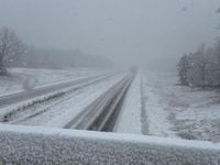
Twin Cities residents can breathe a sigh of relief as a powerful winter storm that was once expected to blanket the area in snow has taken an unexpected turn. Meteorologists have reported that the storm has shifted south, sparing the metro area from significant snowfall.
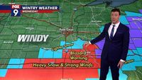
According to Sven Sundgaard, a meteorologist reporting for FOX 9, the forecast models have changed drastically, leading to a gloomy outlook for southern Minnesota instead. The latest guidance indicates that while the Twin Cities might see little or no snow on March 19, 2025, the southern parts of the state and into northern Wisconsin will face blizzard conditions.
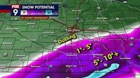
On March 18, Sundgaard noted that “confidence has increased that the narrow swath of heaviest snow will fall across far southeastern Minnesota and into central Wisconsin.” The National Weather Service (NWS) confirmed this shift, downgrading the blizzard warning for several counties around the Twin Cities to a winter weather advisory, leaving places like Le Sueur, Nicollet, and Rice counties with lighter snow expectations.
In stark contrast, blizzard warnings remain in effect for counties south and east of the metro area, with conditions expected to be severe. The storm could bring substantial snowfall, with some areas potentially accumulating more than six inches of snow. The NWS also reported that snow will likely fall in southern Minnesota from Fairmont to Rochester, particularly along Interstate 90.
Wind speeds are predicted to reach high gusts, contributing to reduced visibility for drivers in the affected regions. The heaviest snow is forecasted for March 19, with snowfall rates as intense as one to two inches per hour in southeastern Minnesota. Brent Hewett, another meteorologist at the NWS, explained the evolution of the storm, stating that “Anywhere from a trace in the Twin Cities to an inch or two in southern Dakota County is expected.”
Further complicating the meteorological picture, forecasts indicate that as much as a foot of snow could fall in the worst-affected areas in southern Minnesota and parts of western Wisconsin. While the winter storm threatens to disrupt travel and create hazardous road conditions, the Twin Cities area is more likely to experience just a dusting, barely enough to leave a mark.
Looking ahead, temperatures are predicted to remain cooler yet near or above normal heading into the weekend, with highs around 41 degrees in the Twin Cities on the storm day and rising slightly to 49 degrees by March 20, 2025. Weather models for March 23 hint at another chance for rain or snow as the days advance.
The storm is a reminder of the unpredictable nature of winter weather in Minnesota. Although the immediate impact on the Twin Cities appears negligible, the situation in southeastern Minnesota serves as a warning about the potential for extreme weather conditions exacerbated by climate change. As studies have shown, there is a broader trend of increasingly severe weather directly linked to climate change due to human activity.
BMTN noted that “weather events in isolation can't always be pinned on climate change, but the broader trend of increasingly severe weather and record-breaking extremes seen in Minnesota and across the globe can be attributed directly to the rapidly warming climate caused by human activity.”
Throughout this week, many Minnesotans are reminded to prepare for potential weather disruptions. The National Weather Service and local channels are encouraging safety measures, urging travelers to remain vigilant and avoid unnecessary travel in areas under blizzard advisories.
As the storm system moves northeast, it is expected to weaken significantly by March 20, with calmer and clearer skies forecasted for most regions in the following days. High pressure is likely to dominate the weather, bringing about a much-needed break from harsh winter conditions, with the week ending on a hopeful note for residents in the Midwest.