On Monday, August 25, 2025, the National Hurricane Center in Miami announced the formation of two tropical storms—Juliette in the Pacific Ocean and Fernand in the Atlantic. Though their swirling cloud masses were visible from space and tracked by the vigilant eyes of meteorologists, both storms remained hundreds of miles from any coastline, posing no immediate danger to land or people.
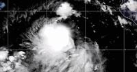
Tropical Storm Juliette emerged in the eastern Pacific, its center located about 470 miles (760 kilometers) southwest of the southern tip of Mexico’s Baja California peninsula, according to the Associated Press. The storm quickly strengthened over the course of the day, reaching maximum sustained winds of 60 mph (95 kph) by Monday afternoon. It was moving in a west-northwest direction at a steady pace of 14 mph (22 kph).
The Miami-based U.S. National Hurricane Center (NHC) reported that, as of Monday, there were no coastal watches or warnings in effect for Juliette. Forecasters emphasized that Juliette posed no immediate threat to land, a point repeated in coverage by multiple outlets. The storm was expected to intensify further, with the potential to become a hurricane by Tuesday, August 26, 2025. However, forecasters also anticipated that any strengthening would be short-lived, with weakening likely to begin on Wednesday.
Satellite imagery provided by the National Oceanic and Atmospheric Administration (NOAA) showed Juliette as a well-defined system, spinning over the open waters of the Pacific. The storm’s development was closely monitored by meteorologists, but its distance from populated areas meant that, for now, Juliette was more a matter for scientific observation than public alarm.
Meanwhile, on the other side of the continent, Tropical Storm Fernand was churning through the Atlantic Ocean. Fernand had formed on Saturday, August 23, 2025, and, like Juliette, was far from land. On Monday afternoon, Fernand was positioned about 485 miles (775 kilometers) east-northeast of Bermuda. The storm packed maximum sustained winds of 60 mph (95 kph) and was heading north-northeast at 14 mph (22 kph), according to the National Hurricane Center and corroborated by reports in the Associated Press.
Fernand’s trajectory kept it well away from any immediate threat to Bermuda or the North American mainland. The NHC expected Fernand to gradually turn more to the northeast as it continued its journey over open ocean waters. Forecasters predicted that the storm would start to weaken by Monday night, potentially transitioning into a post-tropical cyclone by Wednesday, August 27, 2025, and dissipating entirely by Thursday, August 28, 2025.
Despite the presence of two named storms in different ocean basins, the mood among forecasters was calm. There were no coastal watches or warnings issued for either Juliette or Fernand as of Monday, August 25, 2025. This lack of immediate threat was emphasized in every official update and news report, with the National Hurricane Center urging continued monitoring but not raising any alarms for residents along the Pacific or Atlantic coasts.
The emergence of Juliette and Fernand comes in the midst of the 2025 hurricane season, a period when tropical storms and hurricanes are closely tracked by meteorologists and emergency management officials. While the formation of two storms in separate basins at roughly the same time is not unprecedented, it does serve as a reminder of the dynamic nature of the world’s oceans during this time of year.
Forecasters noted that Juliette’s initial wind speeds varied slightly across reports as the storm organized itself. Early on Monday, some sources, such as NOAA’s satellite updates, placed Juliette’s center about 440 miles (708 kilometers) south-southwest of the Baja California peninsula, with maximum sustained winds of 40 mph (64 kph). By later in the day, the storm had strengthened to 60 mph (95 kph) and drifted slightly to the west-northwest, according to subsequent updates from the Associated Press and the National Hurricane Center. This rapid intensification was not unexpected, given the favorable conditions in the open Pacific at this time of year.
Juliette’s projected path kept it moving away from the Mexican coast, and the NHC forecast called for further strengthening through Tuesday, followed by a weakening trend starting on Wednesday. The storm’s movement at 14 mph (22 kph) meant it was not lingering in one place, which can sometimes lead to greater intensification or a change in track toward land. Instead, Juliette was expected to remain a feature of the open ocean, watched closely by meteorologists but not by coastal residents.
Fernand, too, demonstrated the unpredictable yet often harmless nature of many tropical systems. When it formed on Saturday, August 23, 2025, it was already well out to sea, with no threat to populated areas. By Monday, Fernand’s maximum sustained winds had increased to 60 mph (95 kph), and its center was about 485 miles (775 kilometers) east-northeast of Bermuda. The storm was moving north-northeast at 14 mph (22 kph), a course that would take it even farther from land.
Forecasters expected Fernand to begin weakening by Monday night, transitioning into a post-tropical cyclone by Wednesday and dissipating by Thursday. The NHC’s forecast discussion noted that Fernand would turn more to the northeast as it moved away from Bermuda, reducing any remote chance of impact even further. This prediction was echoed in every major news report, with the Associated Press stating, “No coastal watches or warnings were in effect for either storm.”
The formation and tracking of tropical storms like Juliette and Fernand are a testament to the advances in meteorological science and technology. Satellite imagery, computer models, and coordinated international efforts allow for accurate forecasting and early warnings when storms do threaten land. In this case, however, the story was one of vigilance rather than emergency, with forecasters keeping a close eye on the systems but reassuring the public that there was no cause for immediate concern.
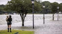
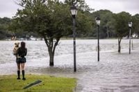
For residents of coastal areas, the presence of named storms far out at sea can bring a mix of relief and caution. While Juliette and Fernand were not expected to bring rain, wind, or waves to shore, the hurricane season is far from over. Meteorologists urge continued attention to official forecasts, as conditions can change rapidly and new systems can develop with little warning.
As of Tuesday morning, August 26, 2025, both Juliette and Fernand remained under close observation by the National Hurricane Center and meteorological agencies worldwide. Their stories serve as a reminder of nature’s power and unpredictability—but also of humanity’s growing ability to anticipate and respond to the challenges posed by the world’s weather.