Tropical Storm Melissa has quickly become the center of attention across the Caribbean, as forecasters and residents alike brace for what could be a dramatic turn in the 2025 Atlantic hurricane season. Over the past two days, the National Hurricane Center (NHC) and several weather teams have been monitoring Melissa’s every move, and the storm’s unpredictable behavior is causing both concern and confusion.
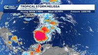
According to the NHC, Melissa first formed over the central Caribbean Sea on October 21, 2025, and immediately set a course toward Jamaica and Haiti. By Wednesday morning, October 22, Melissa was located about 301 to 305 miles south-southwest of Port-au-Prince, Haiti, packing maximum sustained winds between 45 and 50 miles per hour. The storm’s minimum central pressure hovered at 1000 millibars—a sign that Melissa was holding its strength, if not intensifying just yet (as reported by WESH 2 and Gulf Coast News).
But what makes Melissa especially tricky for meteorologists is its shifting center. A Hurricane Hunter aircraft, dispatched to gather real-time data, discovered that the center had re-formed northeast of its previous position. This kind of reorganization can happen when strong upper-level winds—known as wind shear—push the storm’s clouds and rain in one direction, effectively causing the core to “jump.” The Orlando-based WESH 2 team noted that this shift complicates the forecast, making it difficult to predict exactly where Melissa is headed next.
As of Wednesday, Melissa was moving northwest at a sluggish 6 to 7 miles per hour. However, forecasters have little confidence in this motion, as the storm is currently in a weak steering environment. The NHC’s forecast cone is unusually circular, a visual cue that track uncertainty is high. Some computer models suggest Melissa could veer north toward Hispaniola—encompassing Haiti and the Dominican Republic—or Cuba. Others predict a more westerly path, passing south of Jamaica, especially if the storm remains less organized. As Gulf Coast News put it, “A stronger storm is more favored to curve north faster while a weaker storm is more likely to remain in the Caribbean longer.”
Despite these uncertainties, one thing is clear: Melissa is on track to bring significant impacts to the eastern Caribbean. Heavy rainfall—ranging from 5 to 10 inches, with some forecasts from AccuWeather predicting 12 to 18 inches and even localized amounts up to 30 inches—threatens Haiti, the Dominican Republic, and Jamaica through Saturday, October 25. The slow movement of the storm only heightens the risk, as it allows more time for rain to accumulate, raising the likelihood of flash flooding and landslides, especially in mountainous areas (as highlighted by AccuWeather and WESH 2).
“The threat for significant flash flooding and landslides appears to be increasing across the Dominican Republic, Haiti, and Jamaica,” noted one weather update. Meteorologists emphasize that even if Melissa doesn’t immediately strengthen into a hurricane, the danger from flooding and landslides remains severe.
In anticipation, a hurricane watch has been issued for southern Haiti—from the border with the Dominican Republic to Port-au-Prince—while a tropical storm watch is in effect for Jamaica. Local authorities and emergency managers are urging residents to prepare for hazardous conditions, including strong winds, dangerous surf, and power outages. As one meteorologist explained, “Melissa’s winds are strong enough to knock down small trees and cause power outages.”
Looking ahead, Melissa’s intensity is the next big question. The storm is currently battling moderate to strong wind shear and some dry air in the mid-levels of the atmosphere—factors that typically inhibit rapid strengthening. However, the Caribbean Sea is exceptionally warm and humid this year, providing ample fuel for intensification if Melissa can find a pocket of weaker wind shear. The NHC and several weather outlets, including Gulf Coast News, project that Melissa could become a hurricane as early as Thursday, October 23, with the possibility of reaching category 2 strength (winds of at least 96 mph) by early next week.
Forecasters stress that Melissa’s future path and strength are closely linked. If the storm becomes more organized, it may be drawn northward into a gap in the upper-level steering pattern, increasing the odds of a direct hit on Hispaniola or Cuba. If it remains weaker, it could continue west, lingering longer in the Caribbean and potentially threatening Jamaica or even Central America. The uncertainty is so pronounced that, as of October 22, the NHC’s forecast cone covers a broad swath of the Caribbean, and meteorologists are urging residents across the region to stay vigilant.
There’s also the perennial question: Will Florida or the broader U.S. Gulf Coast see impacts from Melissa? For now, most experts say the risk is low. AccuWeather’s Chief Meteorologist Bernie Rayno explained, “The longer Melissa tracks to the west, the greater the chance of an impact on the U.S. The U.S. concern for impacts will be in the Florida Peninsula, especially the lower portion of the Peninsula and the Keys.” However, strong westerly winds from the jet stream are likely to steer Melissa away from Texas, Louisiana, and the panhandles of Mississippi, Alabama, and Florida next week. As of October 22, no watches or warnings were in effect for Florida or the U.S., and the consensus among meteorologists is that steering currents will probably keep the storm away from the peninsula.
Still, the situation remains fluid. The NHC, AccuWeather, and local news stations are updating their forecasts daily, reminding residents to monitor the tropics and have a hurricane plan in place. “Forecasters encourage residents to monitor the tropics and to always be prepared,” noted AccuWeather in its latest update. The Atlantic hurricane season runs through November 30, so there’s still plenty of time for surprises.
As Melissa churns through the Caribbean, its slow pace, shifting center, and uncertain path serve as a reminder of just how complex—and potentially dangerous—tropical systems can be. Meteorologists are watching closely, and so are millions across the region who know all too well the havoc a single storm can bring.