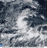
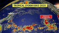
Tropical Storm Kiko, the latest in a string of active systems during the 2025 Pacific hurricane season, officially formed over the eastern Pacific Ocean at 15:00 UTC on August 31, 2025. According to the National Hurricane Center (NHC), Kiko became the 13th named storm of the season, emerging more than 1,000 miles (1,760 kilometers) west-southwest of the southern tip of Baja California, Mexico. As of September 1, the storm was located about 1,910 kilometers (1,185 miles) from Baja California’s southern tip, moving steadily westward over open waters and posing no immediate threat to land.
Forecasters across major outlets, including the Associated Press and UPI, agree that Kiko’s development is being closely monitored, especially given the storm’s potential to rapidly intensify in favorable environmental conditions. The NHC’s latest advisories indicate that Kiko is expected to strengthen and likely reach hurricane status by Tuesday, September 2.
At formation, Kiko’s maximum sustained winds were measured at 40 mph (65 kph), just above the threshold for a tropical storm, and its minimum central pressure was estimated at 1,004 hPa. By early September 1, the NHC reported that Kiko’s winds had increased to 45 mph, with the possibility of continued intensification as it traversed warm ocean waters and encountered low vertical wind shear. UPI, citing the NHC’s 5 a.m. HST update, noted that Kiko’s winds had already reached 60 mph, and the system was still moving west at about 8 mph. The NHC stated, “Steady strengthening is expected, and Kiko is forecast to become a hurricane within the next couple of days.”
Kiko’s westward trajectory is being governed by a strong subtropical ridge to its north, which is acting as a steering mechanism, keeping the storm well away from the Mexican coastline and populated areas. The NHC has not issued any weather watches or warnings for land as of September 1, and experts say the likelihood of Kiko impacting land remains very low in the coming days. As News Arena India reports, “Kiko poses no immediate threat to land as of September 1, 2025.”
Despite its distance from land, Kiko’s evolution is drawing significant attention from meteorologists and hurricane researchers. Warm sea surface temperatures, generally low wind shear, and moist mid-level atmospheric conditions are all contributing to an environment that supports further development. The NHC’s forecast discussion emphasized, “Despite somewhat drier mid-level conditions along its forecast track, the combination of light vertical wind shear, warm sea surface temperatures, and Kiko’s small compact core should allow for strengthening in the short term.”
By September 4 or 5, Kiko is expected to cross into the central Pacific basin, at which point forecasting responsibility will shift from the NHC to the Central Pacific Hurricane Center (CPHC) in Honolulu, Hawaii. The storm’s compact size is another factor being monitored, as smaller systems can sometimes intensify or weaken more rapidly than their larger counterparts. The Watchers, a specialist weather publication, described Kiko as “a compact tropical cyclone expected to remain relatively small in size.”
The broader context of Kiko’s formation is the ongoing activity of the 2025 Pacific hurricane season. The season has already seen multiple named storms, and Kiko’s arrival reinforces the need for ongoing vigilance and preparedness, even when systems are far from land. As News Arena India observed, “Kiko’s formation continues to exemplify the activity seen thus far in the 2025 Pacific hurricane season and justifies the need for ongoing preparedness efforts.”
Meanwhile, meteorologists are also keeping an eye on other developments across the tropics. According to a report from the Houston Chronicle, a tropical wave moved off the coast of Africa on August 31 and was west of Guinea-Bissau as of September 1. The NHC assessed a 40% chance of this wave developing into a tropical depression over the next seven days, though immediate formation chances were low. The next name on the Atlantic hurricane list is Gabrielle, and the wave’s progress will be watched closely as it tracks westward across the Atlantic.
Closer to Mexico, another potential system is brewing near the western coast, with the NHC assigning it an 80% chance of developing into a named tropical storm. If it does, the name Lorena will be assigned. These developments highlight the dynamic nature of the 2025 hurricane season on both sides of the Americas, with multiple systems vying for attention from forecasters and emergency planners alike.
Returning to Kiko, the storm’s movement is expected to remain primarily westward for the next four to five days, steered by the persistent subtropical ridge. Forecast models suggest that as long as Kiko stays over warm waters and avoids cooler sea surface temperatures or dry mid-level air, it could even intensify beyond Category 1 hurricane status. The NHC’s criteria for hurricane classification—winds of at least 74 mph (119 kph)—are likely to be met by early to mid-week, assuming current trends continue.
For those tracking the storm, the NHC and global meteorological agencies will continue to provide regular updates. While Kiko does not threaten land at this time, its progression is a textbook example of how quickly tropical systems can intensify during the peak of hurricane season. The Associated Press reported, “There was no immediate threat to land. Tropical Storm Kiko developed early in the day and is expected to become a hurricane later this week, according to the U.S. National Hurricane Center in Miami.”
As the Pacific hurricane season continues, Kiko serves as a reminder of the unpredictable and sometimes volatile nature of tropical weather systems. Even storms that remain far offshore can offer valuable insights into the mechanics of hurricane formation and intensification, helping meteorologists refine their models and improve future forecasts. For now, all eyes are on Kiko’s journey across the eastern Pacific, with experts poised to adjust their outlooks as new data emerges.
With no immediate threat to land, Kiko’s story is one of scientific interest and ongoing vigilance—a testament to the power and unpredictability of nature during hurricane season.