Far out in the eastern Pacific Ocean, well over a thousand miles from any coastline, a new tropical storm has spun to life. On August 31, 2025, meteorologists at the U.S. National Hurricane Center in Miami confirmed that Tropical Storm Kiko had officially formed, making it the 11th named storm of what’s already been a busy season in the Eastern North Pacific, according to UPI and The Associated Press.
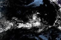
For those living along the coast of Mexico or the southern tip of Baja California, the news might have initially prompted concern. But early reports were clear: there was no immediate threat to land. As the National Hurricane Center noted, Kiko’s center was located about 1,090 miles (1,760 kilometers) west-southwest of the southern tip of Baja California, and even farther from the Mexican mainland. At that distance, the storm was little more than a distant swirl on satellite images—at least for now.
As of 5 p.m. HST on August 31, Kiko’s maximum sustained winds had reached 45 mph (72 kph), according to the National Hurricane Center’s update cited by UPI. Earlier in the day, the storm’s winds were clocked at a slightly lower 40 mph (65 kph), as reported by The Associated Press. Kiko was moving steadily west at a speed of 9 mph (15 kph), a pace that kept it pointed away from populated areas and toward the open ocean.
“Strengthening is expected during the next couple of days, and the system is forecast to become a hurricane by Tuesday,” the National Hurricane Center announced, as quoted by The Associated Press. That would mean Kiko’s winds would need to reach at least 74 mph (about 119 kph)—the threshold for hurricane status. Forecasters anticipated that Kiko would steadily intensify, with UPI noting that the storm is expected to grow to hurricane strength in a day or two, around September 1 or 2.
Despite its growing strength, the National Hurricane Center saw no reason to issue coastal watches or warnings as of August 31. The storm’s remote location and westerly trajectory meant that, for now, it posed no threat to land. “No coastal watches or warnings were issued as of August 31, 2025,” The Associated Press confirmed, echoing the cautious optimism of meteorologists tracking the system.
Still, Kiko’s formation is worth paying attention to—not just for its potential to become a hurricane, but also because it’s part of a larger trend this season. As UPI reported, Kiko is the 11th named storm in the Eastern North Pacific in 2025, a statistic that underscores the region’s heightened activity this year. Each storm brings its own story, and while many fizzle out over the open ocean, others have been known to take unexpected turns, sometimes threatening islands or even the mainland.
Forecasters were already looking ahead to Kiko’s possible journey. According to an NHC discussion cited by UPI, there was a belief that Kiko would likely cross into the central Pacific basin within four to five days from its formation. This westward movement would keep the storm over open water, at least for the immediate future.
But what kind of storm is Kiko, really? John Cangialosi, a forecaster at the National Hurricane Center, offered some insight in the NHC’s discussion. “Kiko is currently a compact system,” he said. “Although it is forecast to get larger, the model guidance suggests that it will likely be on the smaller side through the week.” In other words, while Kiko may pack a punch, it’s not expected to become one of those sprawling, monstrous hurricanes that stretch hundreds of miles across. Instead, it’s likely to remain relatively small, at least for the next several days.
For now, Kiko is a curiosity for meteorologists and weather enthusiasts, a reminder of the power and unpredictability of the world’s oceans. The storm’s formation was first reported by The Associated Press and quickly echoed by outlets including UPI and other regional news sources. As of September 1, 2025, Kiko continued its journey across the Pacific, its winds gathering strength but its path remaining clear of land.
It’s worth noting how quickly information about these storms can change. Tropical systems are notoriously fickle, sometimes weakening just as quickly as they intensify, or shifting course in response to changing atmospheric conditions. That’s why meteorologists keep a close eye on every update from the National Hurricane Center, ready to sound the alarm if a storm’s path veers toward populated areas.
But for now, the story of Kiko is one of distance and potential. The storm’s birth more than a thousand miles from land, its steady westward march, and its likely intensification into a hurricane all make for a dramatic narrative—albeit one that, thankfully, does not currently threaten lives or property. For residents of Mexico, Baja California, and the broader Pacific region, Kiko is something to watch, not something to fear.
Of course, the hurricane season is far from over. The formation of Kiko as the 11th named storm serves as a reminder that the Eastern North Pacific remains active, and that vigilance is always necessary. Meteorologists will continue to monitor Kiko and any other systems that may develop in the coming weeks, ready to issue warnings if conditions change.
For now, though, Kiko is a storm at sea—a powerful but distant force, churning across the Pacific and reminding us all of the ocean’s restless energy. As always, the best advice is to stay informed, keep an eye on official forecasts, and remember that nature can be both beautiful and unpredictable.
With Kiko expected to remain compact and on the smaller side, as noted by John Cangialosi, the immediate outlook is one of cautious observation. The storm’s projected path into the central Pacific basin over the next several days will keep it far from land, but meteorologists will be watching closely for any changes.
In the grand scheme, Kiko’s formation is a testament to the power of modern meteorology and the importance of early warning systems. Thanks to the diligent work of the National Hurricane Center and the timely reporting of outlets like The Associated Press and UPI, the public can stay informed—and, for now, breathe a sigh of relief.
As the 2025 hurricane season continues, storms like Kiko serve as both a warning and a wonder—reminders of the ever-changing dance between sea and sky, and the need to respect the forces that shape our world.