The central Pacific Ocean is currently witnessing an unusually active tropical cyclone season, marked by the simultaneous presence of two named storms for the first time since 2015 and the emergence of its first major hurricane since August 2023. Tropical Storm Keli and Hurricane Iona, both developing rapidly and intensifying, have stirred concerns across the Hawaiian Islands, not for direct landfall threats, but for their indirect impacts on the region’s weather and wildfire risks.
Tropical Storm Keli, situated approximately 790 miles southeast of Honolulu as of July 29, 2025, is moving steadily westward at 15 mph with sustained winds near 40 mph, accompanied by stronger gusts. While the storm is not expected to make landfall on the Hawaiian Islands, its presence is far from inconsequential. Meteorologists and local authorities are keeping a close watch on Keli, primarily due to its potential to strengthen the trade winds that sweep across the islands. This intensification of winds could exacerbate existing drought conditions and elevate wildfire risks, a pressing concern given that over half of Hawaii is currently experiencing drought.
“Keli may stay offshore, but its effect on trade winds could be felt on the islands,” AccuWeather analysts have noted. The increased wind speeds, combined with the dry conditions, create a dangerous mix that could lead to more frequent and severe wildfires. Local officials have urged residents to remain vigilant, especially in drought-stricken areas, advising caution around open flames and fire-prone activities. These warnings come amid a broader context of heightened natural hazards that the islands face this season.
Meanwhile, Hurricane Iona has captured meteorologists’ attention due to its remarkable and rapid intensification. Over the course of just 24 hours—from July 28 to July 29, 2025—Iona surged from a 50-mph tropical storm to a powerful Category 3 hurricane with winds reaching 125 mph. This dramatic 65 mph increase in wind speed places Iona in the top 1% of hurricanes in terms of rapid strengthening, a rare and noteworthy occurrence. Initially, forecasts had pegged Iona to peak as a modest 60-mph tropical storm, but advanced microwave satellite data—technology currently being phased out by the U.S. Navy—revealed structural changes in the hurricane that conventional satellites missed. This new information prompted forecasters to adjust their predictions swiftly, underscoring the importance of cutting-edge technology in storm monitoring.
Despite its impressive strength, Hurricane Iona is not expected to pose a direct threat to Hawaii. Positioned about 735 miles south of Honolulu, the storm is projected to slide well south of the islands, sparing them from the worst of its fury. Alongside Iona and Keli, the National Hurricane Center is monitoring additional systems that could further complicate the Pacific hurricane landscape. One such disturbance, labeled EP98, lies 1,500 miles east-southeast of Hawaii and has a 60% chance of developing into a tropical cyclone within 48 hours. Additionally, two more systems—one off the coast of Mexico and another anticipated to form near Baja California—are being closely watched for possible development over the next week.
These multiple active systems point to a Pacific hurricane season that is both unusually busy and unpredictable. Historically, the central Pacific basin experiences an average of four to five tropical cyclones per season, with about three named storms. However, 2025 has defied expectations. NOAA had forecasted a relatively quiet season with only one to four tropical cyclones, but the current activity suggests a more dynamic and volatile period ahead. This surge in storm activity aligns with patterns seen during El Niño years, which tend to enhance hurricane formation in the central Pacific, though 2025’s exact climatic drivers are still under study.
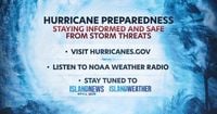
For residents and visitors in Hawaii, the message from meteorologists and emergency management officials is clear: preparedness is essential, even if no storm is currently forecasted to make landfall. The National Oceanic and Atmospheric Administration (NOAA) recommends several precautionary measures to mitigate the impacts of these storms and related hazards. These include assembling sufficient supplies such as batteries, water, medications, and non-perishable foods; verifying that flood and storm insurance policies are current; establishing emergency contacts and evacuation plans; securing homes by trimming trees and fastening loose objects; and staying informed through official channels like the National Hurricane Center and local emergency management offices.
“It’s never too early to get ready,” NOAA emphasized, underscoring the importance of vigilance in the face of an active and uncertain hurricane season.
Beyond Hawaii, the broader tropical Atlantic region is also showing signs of increased activity as August approaches. Several tropical waves have been observed west of Africa, although these currently pose no immediate threat of development. However, as the calendar turns to August—a period historically associated with peak hurricane activity—meteorologists are keeping a watchful eye on these waves for potential intensification as they move westward. The trend suggests that the coming weeks could bring heightened tropical cyclone activity not just in the Pacific but across the Atlantic basin as well.
In sum, while Hawaii may avoid direct hits from the current storms, the indirect effects, especially from Tropical Storm Keli’s influence on trade winds and wildfire risks, demand attention and action. Hurricane Iona’s rapid intensification serves as a stark reminder of the unpredictability of tropical systems and the critical role of advanced monitoring technologies. With multiple systems brewing and more possibly on the horizon, the 2025 hurricane season is proving to be a complex and challenging period for meteorologists and residents alike.
As the Pacific and Atlantic basins continue to churn with tropical activity, the importance of preparedness, awareness, and respect for nature’s power remains paramount.