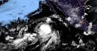
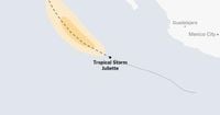
Tropical Storm Juliette spun into existence on Monday, August 25, 2025, in the vast Pacific Ocean, marking the tenth named storm of what’s shaping up to be an active Eastern Pacific hurricane season. According to the U.S. National Hurricane Center (NHC), Juliette formed about 440 miles south-southwest of the southern tip of Mexico’s Baja California peninsula, far from any immediate threat to land. With maximum sustained winds clocking in at 40 mph and higher gusts possible, Juliette was moving west-northwest at 13 mph—a pace and direction that forecasters expected to hold steady over the next couple of days.
For now, Juliette is a storm to watch, not to worry about. As the NHC made clear in its advisory, "No coastal watches or warnings were in effect for Juliette or Tropical Storm Fernand." The agency’s meteorologists predicted some strengthening through Tuesday, August 26, but anticipated that the storm would begin to weaken by Wednesday, August 27. The system is forecast to remain out over the open Pacific, never coming close enough to pose a direct threat to land.
The NHC’s Monday morning update, as reported by Newsweek, noted that tropical-storm-force winds extended up to 60 miles from Juliette’s center. But even with this reach, the storm’s main impact would be confined to the ocean. AccuWeather’s lead hurricane expert Alex DaSilva told Newsweek, "Juliette is not forecast to become a hurricane as it will be moving north into much cooler waters. The storm is not forecast to bring direct impacts (rain or wind) to land." He added, "There is a low chance it could bring some extra clouds to Southern California late this week or early this weekend as it falls apart."
The 2025 Eastern Pacific hurricane season began on May 15 and will run through November 30, paralleling the Atlantic’s timeline but starting a bit earlier. Juliette’s arrival as the tenth named storm makes the season slightly busier than usual at this point. Dan Brown, a hurricane specialist at the NHC, told Newsweek, "The number of named storms season to date is running slightly ahead of schedule (10 vs. 8), but the number of hurricanes and major hurricanes are at the average number for this date. In terms of Accumulated Cyclone Energy (ACE) which measures the strength and duration of storms so far in the eastern Pacific, the season is below normal to date."
Juliette’s formation comes closely on the heels of Hurricane Erin, which had triggered warnings along the U.S. East Coast just last week. While Erin’s proximity to land created anxiety for coastal residents, Juliette’s story is a different one—its trajectory and intensity are being watched primarily by meteorologists and weather enthusiasts, not by those bracing for impact. The NHC, as always, continues to monitor the situation closely, using satellite imagery, radar, and a suite of forecasting tools to track the storm’s strength, size, and path. These technologies allow experts to analyze everything from wind speeds to the potential for storm surge and rip currents, even though none of those hazards are expected to materialize for Juliette.
Meanwhile, the Atlantic basin has its own drama unfolding with Tropical Storm Fernand, which formed on Saturday, August 23, 2025. Fernand was located roughly 360 miles east-northeast of Bermuda, with maximum sustained winds at 50 mph and heading north-northeast at 12 mph. Like Juliette, Fernand is expected to remain over open waters, moving further away from Bermuda and weakening as early as Monday night. Meteorologist James Spann wrote on X (formerly Twitter), "Tropical Storm Fernand, in the open Atlantic with winds of 45 mph, is about 295 miles east of Bermuda. It is moving to the north/northeast at 13 mph, and will stay far from land. It becomes post-tropical Tuesday night." Levi Cowan, another meteorologist, added, "Tropical Storm Fernand has formed (formerly Invest 90L) in the western Atlantic. Fernand will track north-northeastward to the east of Bermuda with modest strengthening expected, limited by some vertical shear. No impacts to Bermuda or Atlantic Canada are expected."
Looking ahead, the NHC is keeping an eye on a disturbance near Juliette with a 20 percent chance of cyclone formation over the next seven days. Their advisory stated, "An area of low pressure is likely to form in a few days well to the south of the southern tip of the Baja California peninsula. Subsequent slow development is possible late this week into the weekend as the system moves westward to west-northwestward at 10 to 15 mph." While it’s far too early to know what this system might become—or if it will ever get a name—it’s a reminder that hurricane season is far from over.
Historical context offers some perspective. Most storms in the Pacific move west, away from mainland North America, as noted by The New York Times. But sometimes, atmospheric patterns can nudge a storm north or northeast toward Baja California and western Mexico. That’s what happened with Hurricane Hilary in 2023, which brought damaging winds and intense rain to Southern California—a rare but memorable event. For now, though, Juliette is expected to stay true to the typical Pacific script, steering clear of land and gradually losing steam as it encounters cooler waters.
Satellite imagery, radar mosaics, and tracking data from the NHC and other agencies provide real-time insights into Juliette’s development. These tools are invaluable for forecasters, helping them determine not just where a storm is, but how strong it is and where it’s likely to go. The NHC’s regular forecast updates, available on its website and social media, keep the public informed—even when, as in Juliette’s case, the immediate risk is minimal.
Despite the lack of direct threats from Juliette or Fernand, the flurry of activity is a wake-up call that hurricane season is in full swing. The NHC’s Dan Brown summed it up: while the number of named storms is running ahead of schedule, the overall energy and number of major hurricanes remain average. That’s a small comfort for now, but as past seasons have shown, it only takes one storm taking an unexpected turn to change everything.
For residents of Southern California, Mexico’s Baja peninsula, and the Atlantic seaboard, the advice is simple: keep an eye on official updates, but don’t lose sleep over Juliette or Fernand. With no watches or warnings in effect and both storms expected to weaken over open water, the summer of 2025’s latest tropical systems are, for now, more a meteorological curiosity than a looming disaster.
As the season continues, forecasters and the public alike will remain vigilant—watching the skies, reading the maps, and hoping that the storms of 2025 stay where they belong: out at sea.