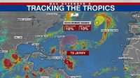
Tropical Storm Jerry, the tenth named storm of the 2025 Atlantic hurricane season, is churning through the Atlantic with growing intensity, raising concerns for the northern Leeward Islands and prompting a flurry of activity from meteorologists and emergency officials across the region. As of Thursday morning, October 9, 2025, Jerry was located approximately 395 miles east-southeast of the northern Leeward Islands, moving west-northwest at a brisk 20 miles per hour, according to the National Hurricane Center (NHC). With maximum sustained winds measured at 65 miles per hour and higher gusts, Jerry is expected to gradually strengthen and could become a hurricane by late Friday or Saturday.
The NHC and several weather outlets, including FOX 13 and FOX 35, report that Jerry's center is forecast to pass near or just to the northeast of the northern Leeward Islands later today and into tonight. This path puts several islands under a tropical storm watch, including Antigua, Barbuda, Anguilla, St. Kitts, Nevis, Montserrat, St. Barthelemy, St. Martin, Sint Maarten, Saba, St. Eustatius, Guadeloupe, and the adjacent islands. Residents in these areas are bracing for tropical storm conditions, which are possible from late Thursday into Friday, and are advised to stay alert for updates as the situation develops.
Rainfall associated with Jerry is expected to be significant. The NHC forecasts two to four inches of rain across the Leeward Islands and the British and U.S. Virgin Islands, with some locations potentially receiving up to six inches. This heavy rain poses a risk of flash flooding, particularly in urban areas and on steep terrain. "This rainfall brings a risk of flash flooding, especially in urban areas and in steep terrain," the NHC emphasized in its latest advisory. The combination of saturated soils and continued rainfall could lead to dangerous conditions for both residents and travelers in the region.
But rain isn’t the only threat. Swells generated by Jerry are already reaching the Leeward and Windward Islands and are expected to spread westward toward the Virgin Islands and Puerto Rico tonight, then on to the rest of the Greater Antilles over the next couple of days. These swells are likely to cause large waves and life-threatening surf and rip current conditions at local beaches, making coastal activities particularly hazardous. According to FOX 13, "Those swells are likely to cause large waves and life-threatening rip currents at local beaches." Beachgoers and boaters are strongly urged to heed warnings and stay out of the water until conditions improve.
Despite Jerry’s steady pace and strengthening forecast, the storm is currently being hampered by moderate to strong wind shear, which has prevented it from intensifying more rapidly. However, meteorologists remain vigilant, as gradual strengthening is still anticipated. Some computer models suggest Jerry could reach major hurricane status (Category 3 or higher), while others predict little change in intensity over the next several days. The NHC notes that tropical-storm-force winds extend outward up to 175 miles from the center, meaning impacts could be felt well away from Jerry’s core.
In a move to gather more precise data, NOAA’s Hurricane Hunters were scheduled to fly into Jerry on Thursday. These missions provide critical real-time information about the storm’s structure, intensity, and potential for further development, allowing forecasters to refine their predictions and issue timely warnings. FOX 35’s Jessica Dobson highlighted, "NOAA's Hurricane Hunters will fly into the tropical storm to investigate on Thursday."
For those in Florida and along the U.S. East Coast, there’s a sigh of relief—for now. The consensus among meteorologists, including FOX 13’s Dave Osterberg, is that a nor’easter tracking up the eastern seaboard will act as a barrier, steering Jerry away from the mainland United States. This powerful system, expected to bring wind gusts of 50-60 miles per hour and heavy rain from coastal North Carolina up to New York City, will push Jerry out to sea, keeping it east of Bermuda and away from Florida. Osterberg explained, "A nor’easter is going to push Jerry out to sea. He added that this is the second time in the past few weeks that one storm pushed another one out."
Still, the unpredictability of hurricanes means that residents and officials remain vigilant. The NHC advises that while the forecast cone illustrates the most likely path of the storm’s center, it does not capture the full width or all potential impacts of the storm. In fact, the center of a storm can travel outside the cone up to 33% of the time, so those in the broader region should monitor updates closely.
Elsewhere in the Atlantic, meteorologists are keeping an eye on Invest 96L, a non-tropical low-pressure system located several hundred miles to the west-northwest of the Azores. While it has a 10% chance of development in the coming week, it poses no threat to North America. Additionally, a trough of low pressure in the Bay of Campeche has moved inland over southern Mexico, producing disorganized showers and thunderstorms, but no tropical development is expected from this system.
The 2025 Atlantic hurricane season, which runs from June 1 to November 30, has been active but not exceptionally destructive for the U.S. so far. Jerry is the tenth named storm this year, but only one of the previous nine has made landfall in the United States. Early forecasts from the National Oceanic and Atmospheric Administration (NOAA) predicted between 13 and 19 named storms, with up to nine becoming hurricanes and as many as five strengthening into powerful Category 5 storms. As the season has progressed, predictions were adjusted slightly downward, but the threat of late-season storms remains, particularly as the focus shifts to the Caribbean and Gulf of Mexico in October due to seasonal patterns like the Central American Gyre.
For now, all eyes remain on Jerry. With tropical storm watches in effect and the potential for hurricane status looming, the coming days will be crucial for the northern Leeward Islands and surrounding areas. Residents are urged to prepare for heavy rain, flash flooding, and dangerous surf while staying tuned to official updates from the NHC and local authorities. As the Atlantic continues to simmer, the region’s resilience and readiness will once again be put to the test.