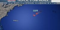
Tropical Storm Andrea has emerged as the first named storm of the 2025 Atlantic hurricane season, marking an early milestone in what forecasters predict will be an above-average year for tropical activity. Officially upgraded on the morning of June 24, 2025, Andrea formed in the central Atlantic Ocean and is already moving away from land, posing no threat to coastal areas.
According to the National Hurricane Center (NHC), Andrea was located approximately 1,205 miles west of the Azores as of 11 a.m. Eastern Time on June 24, with maximum sustained winds near 40 mph and gusts reaching up to 50 mph. The storm is advancing east-northeast at around 17 mph, steadily moving into cooler waters which are expected to weaken it rapidly.
Forecasters anticipate that Andrea will begin dissipating by the evening of June 24 and completely fade out by June 25, with no watches or warnings issued for any land areas. The system’s trajectory keeps it well away from Bermuda, the U.S. mainland, and Canada, ensuring that it remains a remote oceanic event rather than a direct hazard.
"Andrea is a small, gale-force low-pressure system producing showers and thunderstorms over the central Atlantic," the Canadian Hurricane Centre in Halifax explained. Satellite imagery confirms that environmental conditions approximately 1,400 kilometers east of Bermuda are unfavorable for the storm to gain strength, leading to its expected short lifespan.
The formation of Andrea comes slightly later than the average first named storm for the Atlantic, which typically appears around June 20. Phil Klotzbach, a senior research scientist at Colorado State University, notes that while the season is getting off to a later start, the overall outlook remains active.
The National Oceanic and Atmospheric Administration (NOAA) forecast issued in May 2025 projects an above-normal hurricane season for the Atlantic basin. NOAA estimates between 13 and 19 named storms this year, with six to 10 intensifying into hurricanes. Of those hurricanes, three to five are expected to reach major hurricane status, defined as Category 3 or higher on the Saffir-Simpson scale, meaning sustained winds of at least 111 mph.
"NOAA and the National Weather Service are using the most advanced weather models and cutting-edge hurricane tracking systems to provide Americans with real-time storm forecasts and warnings," said U.S. Commerce Secretary Howard Lutnick. "With these models and forecasting tools, we have never been more prepared for hurricane season." The Atlantic hurricane season officially runs from June 1 through November 30, with the peak period of activity typically occurring between mid-August and mid-October.
While Andrea is expected to be short-lived and harmless, forecasters are closely monitoring other systems as well. In the eastern Pacific, the National Hurricane Center is tracking a broad area of low pressure a few hundred miles south of Guatemala’s coast. This system continues to generate disorganized showers and thunderstorms, and environmental conditions suggest a tropical depression is likely to form over the coming weekend. Forecasters assign a 70% chance of development within the next seven days.
Back in the Atlantic, the Canadian Hurricane Centre highlights that historically, between 35 and 40 percent of tropical storms enter the Canadian zone, which stretches from Ontario eastward to Atlantic Canada’s offshore waters. On average, two to four named storms affect this region annually, underscoring the importance of vigilance even in northern latitudes.
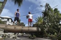
Despite the Pacific having already seen several named storms this year, including Hurricane Erick which struck southern Mexico, the Atlantic's first storm arriving now signals the start of a season that could rival recent busy years. Last year’s 2024 Atlantic hurricane season was especially intense and costly, spawning destructive storms such as Beryl, Helene, and Milton.
Andrea’s formation over warmer-than-normal ocean waters fits the pattern NOAA forecasters cite as a key driver behind the expected busy season. Warmer seas provide the energy necessary for storms to develop and intensify, raising the stakes for coastal communities throughout the Atlantic basin.
For now, Andrea’s trajectory keeps it safely out at sea, and its rapid weakening means it will likely be a footnote rather than a headline. Still, its arrival serves as a reminder that hurricane season is underway and that preparedness remains crucial. As the season progresses, residents from the Caribbean to the eastern seaboard and beyond should stay informed and heed official guidance.
With advanced tracking technologies and improved forecasting models, meteorologists are better equipped than ever to provide timely warnings. Yet, the unpredictability of tropical weather means vigilance is the best defense as the 2025 Atlantic hurricane season unfolds.