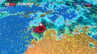
Residents in Western Australia are on high alert as meteorologists forecast the development of a late-season tropical cyclone, named Errol, which is expected to intensify over the weekend. The Bureau of Meteorology (BOM) has issued warnings for coastal communities, particularly in the Kimberley region, as a tropical low hanging off the Northern Territory coast is projected to move southwest across the Timor Sea.
As of Saturday morning, April 12, 2025, the tropical low was located approximately 255 kilometers northwest of the Tiwi Islands, generating wind speeds of up to 95 kilometers per hour. According to Sky News Meteorologist Alison Osbourne, there is a high likelihood that this system will gain strength and potentially become a cyclone by Saturday afternoon.
Osbourne stated, "The system will continue to strengthen at this stage as it continues to glance the WA Kimberly coast. While landfall is not expected in the coming days from this system, gale force winds are." The BOM confirmed that the tropical low is expected to develop into a category 1 cyclone by 4 PM on Saturday, with projections indicating it could escalate to a category 3 storm by Tuesday morning, April 15, 2025.
In light of the impending cyclone, the BOM has issued a tropical cyclone watch for all coastal communities in the region. Emergency WA has also released a cyclone advice warning for areas stretching from Cockatoo Island to Berkeley River, urging residents to prepare for dangerous weather conditions. The alert emphasized the need for locals to secure boats, caravans, and outdoor furniture, while checking their emergency kits.
“Although there is no immediate danger, you need to start preparing for dangerous weather and keep up to date,” the alert stated.
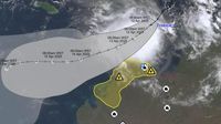
In addition to the cyclone threat, there is a slim chance of a second tropical low forming in waters off the Gulf Carpentaria. Osbourne explained that while it is difficult to predict the exact timing and location of this potential system, it could develop north of the Gulf by Wednesday, April 16, 2025. She noted, "From Wednesday to the end of next week we cannot rule out landfall from this system."
As the cyclone approaches, residents across the nation are experiencing varied weather conditions. In South Australia, sweltering temperatures are expected, while parts of Queensland are bracing for more wet weather. In Sydney, residents enjoyed a sunny Friday with temperatures reaching 28 degrees Celsius, but are now preparing for scattered rainfall throughout the weekend. Conditions are expected to dry out from Monday, April 14, to Tuesday, April 15, with temperatures remaining in the mid-20s.
Meanwhile, Melbourne is set to experience a warm and sunny weekend with temperatures rebounding into the high 30s after a dramatic drop on Friday. Hobart will see dry conditions on Saturday, but residents should be prepared for rain on Sunday. In Perth, temperatures will drop with rainy conditions expected to persist throughout the weekend.
Darwin, on the other hand, is forecast to have showers over the coming week, with temperatures lingering in the low 30s. Meteorologists are closely monitoring the tropical low as it moves southward toward the coast.
The BOM has also reported that the Top End has already experienced a very wet April, with rainfall totals reaching 191.4 millimeters, significantly above the long-term monthly average of 100.5 millimeters. This includes a notable 113.2 millimeters recorded in Darwin on April 2, 2025, surpassing the monthly average.
As the situation develops, authorities are urging residents to remain vigilant and prepared for potential extreme weather impacts, particularly along the Kimberley coastline. With the cyclone's projected path and intensity, communities are advised to stay informed through official channels and adhere to safety recommendations.
In summary, the coming days hold significant weather challenges for residents in Western Australia and the Northern Territory as tropical cyclone Errol approaches. With strong winds and heavy rainfall expected, the BOM and emergency services are working diligently to keep communities safe and informed as this situation unfolds.