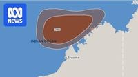
A tropical cyclone is set to form north of Western Australia, potentially delivering damaging wind gusts and heavy rainfall to the Kimberley region. A watch zone currently stretches more than 600 km along the coast from Cockatoo Island to Berkeley River, with residents in those areas advised to prepare for dangerous weather.
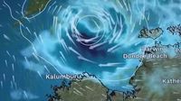
Tropical low 29U, currently located 425 km northwest of Darwin, has a high chance of intensifying into a category one tropical cyclone on Saturday, April 12, 2025. The system is forecast to move southwest across the Timor Sea, remaining off the western Top End coast and then off the northern Kimberley coast. While it is not expected to make landfall, its proximity to the coast could still result in significant impacts.
According to the Bureau of Meteorology, the system will be closest to the Kimberley on Saturday, when bursts of heavier rainfall and gusty winds are anticipated. However, the exact track and intensity of this tropical low will determine the extent of these impacts. The Department of Fire and Emergency Services has indicated that there is no immediate danger but urges residents in the watch zones to begin preparations now.
“Get ready for dangerous weather by preparing your home inside and out,” the department advised. The system is expected to escalate to a category two system by Sunday, April 13, and possibly a category three by Tuesday or Wednesday, April 15 or 16. If it forms, the cyclone will be named Errol.
Another tropical low, designated 30U, may form northeast of Darwin in the eastern Arafura Sea or the Gulf of Carpentaria next week. The Bureau has indicated a low chance of this system developing into a tropical cyclone from late Wednesday, April 16.
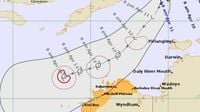
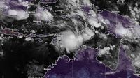
The Bureau of Meteorology has issued a track map for tropical low 29U, which is currently moving south-west towards the remote Kimberley coast. Forecasts suggest that the system may intensify into Tropical Cyclone Errol by Saturday. Authorities have placed a watch zone from Cockatoo Island to Berkeley River Mouth, expecting gales and damaging gusts as well as heavy rainfall to impact the region by Saturday night.
Broome, a coastal town located roughly 2,000 kilometers north of Perth, could see destructive winds and increased rainfall by Monday, April 14. Island and coastal communities have been urged to monitor forecasts closely as the system approaches.
“We do expect the system to intensify into a tropical cyclone on Saturday,” said Bureau forecaster Angeline Prasad. “The chances of this system intensifying into a tropical cyclone have been upgraded to a high chance now.”
The weather system is forecast to track parallel to the Kimberley coastline. Prasad noted that it may recurve later next week, although there are significant uncertainties associated with the tracking of the system beyond Sunday. Increasing showers and thunderstorms are expected in the northern part of the region, with areas such as Kalumburu, Wyndham, and Kununurra potentially receiving rainfall between 20 to 50 millimeters.
“The heaviest falls are most likely going to stay offshore,” Prasad added, “but it is possible we could start to see rainfall in the order of 20 to 50 millimeters associated with the increasing showers and thunderstorms.”
Residents have been encouraged to prepare their emergency kits, including sufficient water and food supplies. “If you haven’t already prepared your kit, this is the time to prepare it,” Prasad said, reminding communities to also identify nearby evacuation centers.
Recent memories of Cyclone Dianne, which struck the West Kimberley last month as a category one system, still linger. Dianne brought significant rainfall to Derby, and communities affected by it remain alert for further weather events.
Another system brewing in the eastern Arafura Sea or Gulf of Carpentaria may also develop into a cyclone by late next week, although it is currently considered a lower risk than tropical low 29U. Meteorologists are keeping a close eye on both systems as the cyclone season in Australia has already seen seven tropical cyclones form since November 2024, marking it as one of the most active seasons in six years.
Weatherzone has reported that the current cyclone season may break records, with the potential for the next cyclone to be named Errol if 29U develops as expected. The formation of these systems is being influenced by an equatorial Rossby wave, which increases the likelihood of storm development near Australia’s northern coastline. Current cloud patterns support the forecasts, and warm ocean waters north of the Kimberley may further intensify the systems.
Forecast models vary regarding the paths of both systems, with some suggesting the Arafura low may track into the Timor Sea. Communities across the Top End and Cape York Peninsula could see rainfall totals between 100 to 200 millimeters, along with thunderstorms.
The Bureau of Meteorology continues to monitor the systems closely, and updates will be provided over the weekend. Residents in affected areas are advised to remain alert and prepared for changing weather conditions.