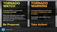
A Tornado Watch Is In Effect Until 4 P.M. For Central Texas
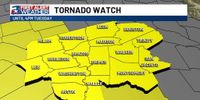
The National Weather Service has issued a Tornado Watch for Central Texas, including Waco and McLennan County, effective until 4 p.m. CT today, May 6, 2025. This watch indicates that tornadoes, along with damaging winds and hail, are possible in and near the watch area.
As residents remain aware of the severe weather possibilities, it is crucial to be Weather Ready. Baylor University encourages everyone to review and discuss their emergency plans to ensure quick action in the event of an emergency. The university's tornado safety procedure guide is readily available for reference.
Actions that individuals can take now include checking their emergency supplies, ensuring their phones are charged, and identifying safe spaces in their homes or residence halls. For those living in Baylor residence halls, it’s essential to know the location of the Severe Weather Assembly Area, which is marked on Building Emergency Plan maps available throughout each building and online.
In case a Tornado Warning is issued, residents should be prepared to act quickly. The City of Waco, McLennan County, and Baylor University have established multiple alert systems to notify the community of an approaching tornado and the necessary actions to take immediately.
The City of Waco-McLennan County Office of Emergency Management operates a network of tornado sirens throughout the area. Baylor University also has its outdoor notification system, which includes sirens on its campus. These sirens are activated during a tornado warning or if a tornado is imminent.
In addition to sirens, alerts will be communicated through local media, weather radios, and Wireless Emergency Alerts (WEA). Baylor will activate its multi-tiered Baylor Alert Emergency Notification System, which includes various communication methods such as:
- Outdoor Notification System (Main Waco Campus Only)
- Baylor Alert email notification to Baylor email accounts
- Baylor Alert text messages to cellphones
- Audio messages to cellphones or other telephones
- Notices on Baylor’s main website
- Official Baylor social media channels
- Baylor Information Line audio recording
During severe weather, the safest procedure indoors is to seek shelter immediately on the ground floor in an interior room. Residents are advised to avoid using elevators and to stay away from windows, doors, and outside walls. It’s recommended to avoid wide-span roof areas such as auditoriums, gymnasiums, dining halls, and large hallways.
In residence halls, staff members will gather residents in the Severe Weather Assembly Areas, where they should bring blankets for protection against debris. Residents should remain in these areas until the tornado passes and an All Clear is issued via Baylor Alert.
If caught outdoors, individuals should seek indoor shelter immediately. If that’s not possible, lying flat in a ditch or low spot is advised. Anyone in a flat area caught in a tornado's path should always move at right angles to the tornado's path.
For individuals with mobility impairments or physical disabilities, supervisory personnel and course instructors are responsible for escorting them to safety during a tornado warning. Elevators may be used to transport individuals with mobility impairments to safer locations. Those unable to use stairs should move to an interior location without windows and contact the Baylor University Police Department for assistance.
The weather situation is further complicated by a severe thunderstorm watch that has been issued for a large part of Central Texas, extending into parts of the Hill Country. Initially expected to end at 10 a.m. Tuesday, this watch has now been extended until noon. Cities under this watch include Austin, Round Rock, San Marcos, Burnet, Fredericksburg, Boerne, Hondo, Killeen, Brownwood, San Angelo, and Abilene.
These thunderstorms are expected to develop and move through the watch area throughout the morning. The strongest storms could produce tennis-sized hail, wind gusts up to 65 mph, and a couple of tornadoes. Earlier, a tornado watch had been issued for parts of West Texas and the Hill Country, but that watch expired at 4 a.m. Tuesday.
As the storms progress eastward, San Antonio and the surrounding areas are likely to experience storm activity, particularly between 4 and 9 a.m. Tuesday. Overall storm chances are about 50%, meaning while rain isn’t guaranteed, any storms that develop could be severe.
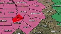
In addition to the tornado watch, several counties across Central Texas are under various warnings and advisories as storms roll through the area. A Tornado Warning issued earlier in the morning has expired, but a Tornado Watch remains in effect for portions of the area, including Travis and Williamson counties.
A Severe Thunderstorm Warning is currently in effect for Bell and Milam counties until 11:45 a.m., while a Flood Advisory is in effect for San Saba and Mason counties until 11:30 a.m., and for Williamson, Gillespie, Hays, Blanco, Travis, Llano, and Burnet counties until 1:15 p.m.
As the weather system continues to evolve, residents of Central Texas are urged to stay vigilant and keep an eye on local forecasts for updates on storm developments. With the potential for severe weather, preparedness is key to ensuring safety during these turbulent times.