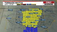
A tornado watch is in place for a large portion of Oklahoma until 1 a.m. on Sunday, March 30, 2025. As of 7:50 p.m. on Saturday, March 29, 2025, several counties are under this watch, including Atoka, Blaine, Bryan, Caddo, Canadian, Carter, Cherokee, Cleveland, Coal, Comanche, Cotton, Craig, Creek, Delaware, Garfield, Garvin, Grady, Hughes, Jefferson, Johnston, Kay, Kingfisher, Lincoln, Logan, Love, Major, Marshall, Mayes, McClain, McIntosh, Murray, Muskogee, Noble, Nowata, Okfuskee, Oklahoma, Okmulgee, Osage, Ottawa, Pawnee, Payne, Pittsburg, Pontotoc, Pottawatomie, Rogers, Seminole, Stephens, Tulsa, Wagoner, and Washington.
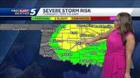
Meteorologist Sabrina Bates has indicated that Oklahoma could face severe storms on Saturday night. The risk of severe weather has been upgraded to a level two slight risk, which includes the Oklahoma City metro area extending into North Central Oklahoma and reaching towards the northeastern part of the state near Tulsa. Bates noted that storms are expected to initiate around 7:00-8:00 p.m. on Saturday, continuing for several hours and wrapping up by about 1:00-2:00 a.m. on Sunday.
"We're watching a severe weather risk; it has been upgraded and expanded to a level two slight," Bates stated. As the storms develop, there is a significant hail threat, with most storms producing hail about the size of ping pong balls, and some areas potentially seeing hail as large as golf balls.
In addition to the hail concern, there is a low to medium tornado risk, rated a 4 on a scale of 1 to 10, particularly from the Oklahoma City metro area up towards Tulsa. Bates explained that damaging winds could also be a factor, with gusts reaching up to 70 miles per hour. "We're going to be watching for those storms to start going up around 7:00-8:00 p.m.," she added.
The storm coverage is expected to expand rapidly around 9:00-10:00 p.m. on Saturday, with the best chance for severe weather predicted along the I-40 corridor and towards the north. "Some isolated storms may develop southwest of the metro, possibly near I-40 up towards Kingfisher, Enid, and over towards Ponca City," Bates said.
As the evening progresses, the coverage of storms will likely become more scattered, particularly along I-35 from Ponca City down to the north side of the Oklahoma City metro area. The meteorologist emphasized that the severe weather threat is expected to persist until about midnight to 1 a.m., with storms moving out of the area by 2:00-3:00 a.m. on Sunday, March 30, 2025, but still affecting eastern Oklahoma.
Residents in the affected areas are urged to stay tuned to local weather updates and take necessary precautions as these storms develop. The National Weather Service has advised that those in the tornado watch area should remain vigilant and be prepared for rapidly changing weather conditions.
This severe weather event highlights the unpredictable nature of springtime in Oklahoma, where conditions can shift quickly, leading to potential hazards. As always, preparedness is key in facing such weather challenges.