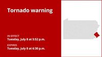
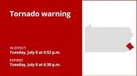
On Tuesday, July 8, 2025, residents of Bucks County and surrounding areas in southeastern Pennsylvania faced a tense and potentially dangerous weather situation as multiple tornado warnings were issued throughout the afternoon and early evening. The National Weather Service (NWS) issued an updated tornado warning at 5:52 p.m. that remained in effect until 6:30 p.m., covering Bucks, Montgomery, and Philadelphia counties. This warning was prompted by a severe thunderstorm capable of producing a tornado, located over Bryn Athyn, approximately 10 miles northeast of Philadelphia, moving east at 30 miles per hour.
The NWS described the storm as capable of producing flying debris, which posed a significant danger to anyone caught without shelter. Mobile homes were at risk of being damaged or destroyed, and damage to roofs, windows, vehicles, and trees was likely. The affected areas included a broad swath of communities such as Philadelphia, Trenton, Bensalem, Ewing, Bristol, Hatboro, Yardley, Newtown, Tullytown, Langhorne, Bryn Athyn, Ivyland, Washington Crossing, Feasterville-Trevose, Northeast Philadelphia, Feasterville, Woodside, Richboro, Langhorn, and Levittown.
Residents were urged to take immediate safety precautions. The NWS advised, "Take cover now! Move to a basement or an interior room on the lowest floor of a sturdy building. Avoid windows. If you are outdoors, in a mobile home, or in a vehicle, move to the closest substantial shelter and protect yourself from flying debris." The warning emphasized that the cluster of thunderstorms was capable not only of producing tornadoes but also of widespread significant wind damage. Additionally, torrential rainfall accompanied the storm, increasing the risk of flash flooding in the area, with officials warning against driving through flooded roadways.
Earlier in the afternoon, at 5:20 p.m., another tornado warning had been issued by the National Weather Service in Mount Holly, New Jersey, which applied to Chester, Delaware, Montgomery, and Philadelphia counties. This warning lasted until 5:45 p.m. and was triggered by a severe thunderstorm located over King Of Prussia, 14 miles northeast of West Chester, moving east at 40 miles per hour. Weather spotters reported a funnel cloud, and the threat included hail as large as one inch. The impacted locations included Philadelphia, Norristown, West Norriton, East Norriton, Conshohocken, Hatboro, Ambler, Jenkintown, Rockledge, Abington, Bryn Athyn, Willow Grove, Valley Forge, Plymouth Meeting, Chestnut Hill, King Of Prussia, Germantown, Paoli, Radnor Township, and Horsham.
Throughout the day, a First Alert was issued for all neighborhoods in the region, warning residents of the dual threat posed by dangerous heat and severe storms. Temperatures soared into the triple digits, with feels-like readings ranging from 100° to 105° Fahrenheit. A cold front slowly moved over the region, creating conditions ripe for severe storms between 3 p.m. and 9 p.m. The main hazards were damaging wind gusts and flooding downpours, compounding the threat posed by the tornado warnings.
As the evening progressed, the original tornado warning for Bucks County expired at 6:15 p.m. and was replaced by a severe thunderstorm warning. This new alert cautioned residents about continued flooding rains and strong winds, signaling that while the immediate tornado threat had lessened, hazardous weather conditions persisted. The National Weather Service canceled the tornado warning for parts of southeastern Pennsylvania, including East central Montgomery County, southeastern Bucks County, and northeastern Philadelphia County, noting that no tornadoes had been confirmed to have touched down as of Tuesday afternoon. However, officials continued to advise caution due to the strong storms moving through the area.
Understanding the difference between a tornado watch and a tornado warning proved crucial for residents during this volatile weather event. A tornado watch serves as an advance notice that conditions are favorable for tornado formation, urging people to review emergency plans, ensure supplies are ready, and identify safe rooms. Watches often cover large areas and are issued by the Storm Prediction Center.
In contrast, a tornado warning indicates that a tornado has been spotted or detected by radar, representing an immediate threat to life and property. Warnings are more localized, typically covering the size of a city or small county, and require swift action to seek shelter. The National Weather Service stressed the importance of moving to an interior room on the lowest floor of a sturdy building, away from windows, and seeking the nearest substantial shelter if outdoors, in a vehicle, or in a mobile home.
Safety tips provided by the National Weather Service emphasized quick and decisive action. At home, residents should go to basements, storm cellars, or interior rooms without windows. At work or school, following tornado drill procedures and moving promptly to designated shelters was advised. For those caught outdoors, finding shelter inside a sturdy building was paramount, as structures like sheds, storage units, mobile homes, and tents offer little protection. Drivers were urged not to attempt outrunning tornadoes but to seek shelter in a sturdy building or, if impossible, to lie flat in a low-lying area while protecting their heads.
Experts also highlighted the importance of preparation ahead of tornado season. Staying informed through local news, NOAA Weather Radio, or community alert systems can provide timely warnings. Establishing family communication plans, selecting secure shelter areas, conducting regular drills, and reinforcing safe rooms can significantly improve safety outcomes. Additionally, taking CPR training and encouraging community preparedness were recommended to help others in emergencies.
The severe weather on July 8, 2025, served as a stark reminder of nature’s power and the importance of readiness. While no tornado touchdowns were confirmed, the combination of extreme heat, severe thunderstorms, heavy rains, and tornado threats created a challenging environment for residents of southeastern Pennsylvania and parts of New Jersey. The National Weather Service and local officials continue to monitor conditions closely, urging vigilance and preparedness as storm seasons progress.


