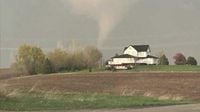
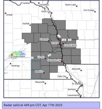
OMAHA, Neb. (WOWT) - Severe weather swept through Omaha and surrounding areas on Thursday evening, April 17, 2025, as tornado warnings were issued across multiple counties in Nebraska and Iowa. The National Weather Service confirmed that a tornado touched down in Douglas County, near Omaha, prompting urgent alerts and safety measures for residents.
At approximately 7 p.m., tornado sirens echoed through Omaha, Bennington, and Elkhorn, leading many to seek shelter. Reports indicated that people at Eppley Airfield took cover for about 15 minutes as the storm approached. The tornado was tracked about seven miles east of Bennington, near Florence, according to the National Weather Service.
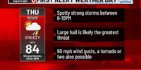
The day had started with warnings of severe thunderstorms, which intensified as the afternoon progressed. High winds had already caused significant dust clouds in Dodge County, prompting drivers to pull off Highway 30 near Rogers and North Bend. By 6 p.m., a tornado warning was officially issued for Dodge County as meteorologists monitored the rapidly changing weather conditions.
As the storm moved toward Douglas County, wind speeds were reported to reach as high as 80 miles per hour, creating hazardous conditions. The storm also brought large hail, with reports of hailstones measuring between 2 to 3 inches in diameter. In Fremont, eyewitnesses confirmed sightings of baseball-sized hail, leading to property damage and safety concerns.
Radar indicated that as the storm progressed into Douglas County, the hail threat began to diminish slightly, with estimates dropping to 1 to 2 inches. However, meteorologists warned that the potential for severe storms remained, advising residents to stay alert.
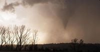
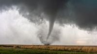
Bill Schammert, a KETV anchor, was actively tracking the storm and captured images of what appeared to be a tornado on the ground. He reported that the tornado lifted as it moved east along Highway 36, but the threat was far from over. Dramatic videos shared on social media platforms, including X (formerly Twitter), showed the massive twister wreaking havoc in the area.
The National Weather Service had issued tornado watches and warnings not only for Douglas County but also for Washington County in Nebraska and Pottawattamie County in Iowa. These alerts were part of a broader warning system in place across the region as severe weather continued to develop.
Emergency crews were deployed to assess the damage caused by the tornado, particularly near Fort Calhoun in Washington County. As the tornado moved toward Crescent, Iowa, just outside Omaha, officials worked diligently to evaluate the extent of the destruction.
Earlier in the day, Omaha residents had been placed on high alert as a strong line of thunderstorms approached from the west. The situation escalated quickly, with meteorologists predicting the possibility of isolated severe storms throughout the evening. By 10 p.m., there was still a chance of one last strong storm moving through the area before conditions calmed down.
As the storm system continued to develop, the Omaha metro area remained under a Tornado Watch until midnight. The forecast indicated that the ingredients necessary for tornadic activity were present, raising concerns among local officials and residents alike.
In addition to the risk of tornadoes, damaging gusts were anticipated, with wind speeds reaching up to 60 mph. The primary concern, however, remained the threat of large hail, with meteorologists warning of hailstones that could be as large as baseballs.
As the storm subsided, the following day, Friday, April 18, 2025, was expected to be cooler, with high temperatures only reaching the lower 50s. Cloud cover and a northwest wind would dominate the weather, making for a stark contrast to the severe conditions of the previous evening.
Looking ahead, rain was forecasted to continue on and off through Easter Sunday, April 20, 2025, further complicating the weather situation in the region. Meteorologists advised residents to remain vigilant as weather patterns shifted and to stay informed through local news outlets and weather apps.
The severe weather event serves as a reminder of the unpredictability of spring storms in the Midwest. As communities recover from the impacts of the tornado, emergency services will continue to monitor conditions and provide updates to keep residents safe.
As the situation develops, local officials encourage everyone to stay prepared and heed any warnings issued by the National Weather Service. With the potential for more severe weather in the coming days, staying informed is crucial for safety.