On Thursday, September 25, 2025, the Hudson Valley found itself at the center of a dramatic weather event as a tornado touched down in the hamlet of Hazel, located in the town of Rockland, Sullivan County. According to the National Weather Service (NWS) in Binghamton, the tornado was radar-confirmed at precisely 12:21 p.m., marking the seventh such event in New York state this year. For residents of the region, it was a tense afternoon as warnings blared and skies darkened, but remarkably, the day ended with no reported widespread damage or injuries.
The tornado’s path began near Hazel and moved northeast, prompting a Tornado Warning for North-Central Sullivan County that remained in effect until about 12:45 p.m. The NWS also issued a warning for Delaware County just after noon, urging everyone in the area to seek shelter immediately. As the warning was broadcast, emergency officials and meteorologists emphasized the seriousness of the situation. "The weather turned hazardous quickly," the NWS noted, underscoring the speed with which conditions deteriorated.
Despite the ominous warnings, the aftermath was less severe than many had feared. Sullivan County EMS Coordinator Alex Rau reported, "Initial reports indicated no widespread damage." However, there were moments of real danger. In the Beaverkill area, trees toppled onto a power line, trapping a person inside their car. Thanks to the swift response of emergency crews, the individual was rescued safely, a testament to the preparedness and professionalism of local first responders.
Power outages were another concern. NYSEG, the local utility, confirmed that some residents in Sullivan County lost electricity during the storm, but power was restored to all affected customers soon after, as reported by Spectrum News. The quick recovery of services was a relief for many, especially given the unpredictable nature of severe storms in the region.
While the tornado in Hazel was the most dramatic event, New York City and the broader tri-state area were not spared from the wild weather. FOX 5 NY and NBC New York both reported that Thursday brought a severe weather threat to the city, including the risk of rain, thunderstorms, and even isolated tornadoes. "We're still going to be dealing with showers and storms into the early part of the night," said Nick Gregory of FOX 5 NY, as forecasters warned that some storms could reach strong to severe levels. Hazards included damaging wind gusts, flooding, lightning, and, of course, the potential for tornadoes.
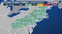
In fact, the NWS estimated a 2 to 4 percent risk of tornadoes across virtually the entire region, with the exception of parts of Long Island. Hourly radar outlooks from NBC New York showed the progression of storms throughout the afternoon and evening, keeping residents on alert. New York City itself received about one-third of an inch of rain in the 24 hours leading up to the event, while areas like Scranton saw nearly three inches dumped in a single day.
As the storms rolled through, the NWS in Mount Holly forecast that showers and thunderstorms would continue into the night, gradually weakening as they moved toward the coast. The cold front responsible for the day’s chaos was expected to exit off the East Coast by Friday, bringing an end to the rainy weather by Saturday. But as anyone who’s lived through a New York fall knows, more unsettled weather was already looming on the horizon for the weekend.
Meanwhile, meteorologists were keeping an eye on developments far out in the Atlantic. Hurricane Gabrielle, recently downgraded to a post-tropical cyclone, was still packing sustained winds of 70 mph less than 500 miles west of the Azores, according to FOX Weather. The storm, though no longer officially a hurricane, remained a significant threat with heavy rain and high winds. At the same time, Tropical Storm Humberto was churning across the ocean and was expected to strengthen into a major hurricane—Category 3 or higher—in the coming days. The Atlantic hurricane season, it seemed, was far from over.
Back in Upstate New York, the tornado in Hazel was just the latest in a string of such events this year. As Bill Kardas, meteorologist for WKTV in Utica, explained, it was the seventh tornado touchdown in the Empire State in 2025. The largest so far had been an EF-2 twister with winds up to 115 mph that struck Phelps, Ontario County, on July 7. That storm tore off two roofs but, fortunately, left no one injured. Tragically, another tornado—a more modest EF-1—claimed three lives in Oneida County on June 22, including two young children. The Enhanced Fujita scale, used to rank tornadoes from EF-0 to EF-5, is based largely on wind speeds, and most tornadoes in New York tend to fall into the EF-0 or EF-1 categories, with winds generally 110 mph or less. As of Thursday, the NWS had not yet determined the classification for the Hazel tornado, but a preliminary storm survey was scheduled for Friday.
For those wondering about the frequency of such events, the University at Buffalo notes that New York averages about nine tornadoes per year—far fewer and generally less intense than in the tornado-prone Great Plains or Midwest. Still, last year saw an unusually high number, including a record-breaking 16 tornadoes in Upstate New York in a single week, the most since official records began in 1950. Hazel, located about 60 miles northeast of Poughkeepsie near the Willowemoc Wild Forest, now joins the list of New York communities touched by these rare but memorable storms.
Elsewhere in the region, Wayne County, Pennsylvania, also faced a tornado warning on Thursday. At 11:39 a.m., the NWS issued a warning for the area, citing a severe thunderstorm capable of producing a tornado near Damascus, moving northeast at 35 mph. The warning highlighted the dangers of flying debris, damage to mobile homes, roofs, windows, and vehicles, and the likelihood of tree damage. Residents in the path—including Callicoon, Hortonville, Fosterdale, Jeffersonville, and White Sulphur Springs—were urged to seek shelter immediately. The NWS stressed, "Take cover now! Move to a basement or an interior room on the lowest floor of a sturdy building. Avoid windows."
With severe weather events seemingly on the rise, the distinction between a tornado watch and a tornado warning has never been more crucial. A watch means conditions are right for tornadoes to form—time to review emergency plans and stay alert. A warning, on the other hand, means a tornado has been spotted or detected by radar and immediate action is required. The NWS and local officials continue to urge everyone to stay informed, have a family emergency plan, and know where to seek shelter when warnings are issued.
As the weather settled and power was restored, the communities of Sullivan County and beyond breathed a collective sigh of relief. While the tornado in Hazel will be remembered as a close call, it also serves as a timely reminder of the importance of preparation, vigilance, and community resilience in the face of nature’s unpredictable fury.