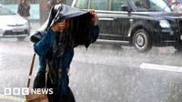
A yellow thunderstorm warning has been issued across large swathes of England and Wales for Saturday, June 7, 2025, as the UK braces for a day of intense downpours, lightning, hail, and strong gusty winds. The Met Office's alert covers most of southern England, parts of the Midlands, and much of South Wales, running from 9am until 6pm, with forecasters warning of potential disruption to transport, power outages, and localized flooding.
Saturday’s weather marks a sharp contrast to the record-breaking spring the UK has just experienced. Provisional data indicates this spring was the warmest on record, with temperatures surpassing the long-term average by 1.4°C and the driest in over 50 years. Across the UK, the average temperature reached 9.5°C (49.1°F), beating the previous record set in 2024. All four nations saw temperature records shattered, with Northern Ireland 1.64°C above average, Scotland 1.56°C, Wales 1.39°C, and England 1.35°C higher than usual.
Despite this warmth, rainfall was scarce. England recorded just 32.8mm of rain in May alone — its driest month in over a century — and the UK as a whole saw only 128.2mm across March, April, and May, the lowest spring total since 1974. Yet on Saturday, some areas could receive more rain in just a few hours than they did across the entire month of May, with forecasts predicting 10 to 15mm of rain in under an hour and totals reaching 30 to 40mm from successive showers and thunderstorms.
Met Office Chief Meteorologist Dan Suri explained the complexity of forecasting thunderstorms: “While brisk winds ensure most places in the warning area will be hit by showers, not all places will see thunderstorms. In this case it’s difficult to predict where exactly thunderstorms will hit because they are small and fast changing. One analogy we use to picture the complexity of this forecasting challenge is comparing it to boiling a pan of water and having to guess exactly where and when the bubbles will appear. We know some will, but only in certain places, and that is why thunderstorms are so hard to predict.”
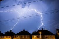
The thunderstorms are expected to bring frequent lightning, hail, and strong gusty winds, which could cause damage to buildings and lead to short-term power outages. The Met Office has warned that these intense weather conditions may disrupt transport services, with delays likely on trains and buses. Driving conditions could also deteriorate due to spray and standing water, increasing journey times and raising the risk of accidents. Motorists are advised to slow down, increase following distances, and avoid flooded roads, as just 30cm of moving water can float a car.
Saturday’s storms will be driven by a deep area of low pressure moving in from the Atlantic early in the morning. This system will spread rain-bearing frontal systems from west to east across the UK throughout the day before clearing out into the North Sea by evening. Behind the main frontal system, skies are expected to clear somewhat, offering a mix of sunny spells and scattered showers, although these too may be heavy and thundery at times.
Among the regions most at risk of heavy and slow-moving thunderstorms are the Midlands, Wales, and Merseyside. Western areas should see conditions improve by mid-afternoon as the system moves eastwards. While the yellow warning is the lowest level issued by the Met Office, it signals a significant probability of severe weather with potential impacts on daily life.
Saturday’s cooler and wetter weather also contrasts with the start of meteorological summer, which began on June 1. Temperatures are expected to drop, with lows of 10°C forecast in London and 7°C in Glasgow. This unsettled spell follows a spring that was not only the warmest but also the sunniest on record, with over 600 hours of sunshine recorded across the UK between March 1 and May 27.
Looking ahead, Sunday, June 8, is expected to be much quieter and drier for most, with sunny spells and only a few light, isolated showers, mainly in northern and eastern areas. The new working week will begin with sunshine and showers on Monday, primarily in the north, while the south enjoys drier weather.
However, the unsettled weather pattern may persist. Forecasters have indicated the possibility of a new low-pressure system arriving from the Atlantic on Tuesday, June 10, potentially pushing another weather front over the UK. This could bring wetter and windier conditions, especially to northwestern areas. Following this, warmer air is expected to flow in from the south from Wednesday onwards, with temperatures possibly reaching the high 20s°C in the southeast by Thursday, June 12. Yet, this warm air may also bring the risk of further thunderstorms, potentially leading to an unsettled end to the week.
Despite the stormy weekend, the Met Office’s three-month outlook predicts a hotter than usual summer for the UK, with an increased chance of heatwaves and heat-related impacts. The likelihood of a hot summer is estimated to be 2.3 times higher than normal, with average temperatures ranging from 10°C to 17°C across the country, and the southeast expected to experience the warmest conditions.
Thunderstorms are caused by unstable air rising rapidly, forming towering thunderclouds where water droplets freeze into hail and collide, generating static electricity that discharges as lightning. The accompanying thunder results from rapidly expanding air heated by the lightning bolt. The UK typically experiences between 200,000 and 300,000 lightning strikes annually, and climate experts expect this frequency to increase as global temperatures rise.
The Met Office advises people to stay informed by monitoring weather updates and warnings, unplug non-essential electronics before storms, secure outdoor items, and seek shelter indoors or in vehicles during thunderstorms. If caught outside with no shelter, crouching low with feet together and hands over ears is recommended, avoiding lying flat on the ground. After storms, caution is urged around downed power lines and damaged structures.
As the UK faces this dramatic shift from a record-breaking spring to a stormy weekend, residents are reminded to prepare for the challenges ahead and stay safe amid the unpredictable weather.