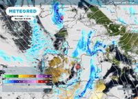
On April 15, 2025, Météo-France issued a yellow alert for thunderstorms, affecting 44 departments across the eastern half of France. This alert indicates that weather conditions could become hazardous, particularly with the risk of localized flooding and strong storms.
The departments under alert include Ain, Aisne, Allier, Alpes-Maritimes, Ardèche, Ardennes, Aube, Aude, Aveyron, Bouches-du-Rhône, Cantal, Côte-d'Or, Doubs, Drôme, Gard, Hérault, Isère, Jura, Loire, Haute-Loire, Lozère, Marne, Haute-Marne, Meurthe-et-Moselle, Meuse, Moselle, Nièvre, Nord, Pas-de-Calais, Puy-de-Dôme, Pyrénées-Orientales, Bas-Rhin, Haut-Rhin, Rhône, Haute-Saône, Saône-et-Loire, Savoie, Haute-Savoie, Somme, Var, Vaucluse, Vosges, Yonne, and Territoire de Belfort.
Rain is expected to start early in the day, particularly in the Rhône valley, where accumulations could exceed 50 mm. Thunderstorms are predicted to develop in the afternoon, moving northward towards Burgundy. As the day progresses, these storms could also impact regions in Provence-Alpes-Côte d'Azur and Franche-Comté, potentially reaching Alsace by evening.
The situation in Nièvre is particularly concerning, where the same yellow alert has been extended for a second consecutive day. The alert will be active from 2 PM to 8 PM, urging residents to remain vigilant and cautious, especially those engaging in outdoor activities.
In the Marne and Ardennes, alerts will take effect at 4 PM and remain until 10 PM and 7 PM, respectively. After a rainy afternoon, thunderstorms are expected to hit the eastern half of Marne, particularly from Vitry-le-François to Val-de-Vesle, including Châlons-en-Champagne and Sainte-Menehould. The Reims region will also experience the risk of storms.
In the Ardennes, thunderstorms are predicted to be limited to the southeast area, particularly around Lac de Bairon. Meanwhile, the Aisne department will see a shorter alert period, with the potential for storms developing later in the day.
As the weather system progresses, a significant amount of rain is anticipated across the affected areas. Rainfall totals from Monday to Wednesday could reach between 90 mm and 118 mm in the most impacted regions. Météo-France has warned that the thunderstorms could produce heavy rainfall in a short time, leading to significant runoff.
In addition to thunderstorms, strong winds are expected in the western parts of France, with gusts reaching between 50 and 70 km/h, and potentially up to 90 km/h in localized areas. Snowfall is also forecasted in mountainous regions such as the Massif Central and the Pyrenees, with snow levels dropping to between 900 and 1000 meters.
The yellow alert is the second tier on Météo-France's four-level warning scale, indicating that while the weather may pose localized dangers, it does not present major risks to the population at large. However, residents are advised to stay informed about the evolving situation and heed safety instructions from local authorities.
As the day unfolds, it is crucial for those in the affected areas to remain vigilant. Outdoor activities should be reconsidered, and individuals are encouraged to monitor weather updates closely. With the potential for severe thunderstorms and heavy rain, safety must be the priority.
The forecast also indicates that the weather will remain unsettled in the coming days, with heavy showers expected to continue into Wednesday, particularly in the southeastern regions. This could lead to further complications as the ground becomes saturated from the ongoing rainfall.
In summary, the weather forecast for April 15, 2025, paints a picture of a turbulent day ahead for much of France, particularly in the eastern regions. Residents are urged to take precautions and stay updated on the latest weather advisories as thunderstorms and heavy rains threaten to disrupt daily life.