Across China, the weather has taken a significant turn starting this week, as warm high-pressure ridges establish control over much of the country's climate. This transition heralds sunny skies and notable temperature increases, with the cumulative rise expected to exceed 10°C across Northwest China and most regions of the central and eastern parts of the nation.
Particularly, areas north of the Yangtze River are forecasted to see average temperature increases surpassing 15°C. Following this predicted warming, major regions including Beijing, Tianjin, Hebei, and Shandong are anticipated to officially embrace the arrival of spring.
According to reports, the cold spells affecting many parts of the country recently are coming to an end as high-pressure systems dominate, allowing for sunny days to take center stage. Between March 17 and March 18, heavy winds along with rain and snow will still impact Southwest China, with Tibet and western Sichuan bracing for heavy snow or blizzards.
During the upcoming week, temperatures are expected to soar significantly. Predictions indicate areas such as northeastern Inner Mongolia, northern Hebei, and western Liaoning may experience temperature spikes of over 20°C by the end of the week, right around March 22. Meanwhile, regions such as southern North China and Huanghuai may witness maximum temperatures rising above 25°C.
Taking Shenyang as an example, where the maximum temperature only reached 2.7°C on March 16, projections now show it could hit 20°C within the next week, offering residents significant day-to-night temperature contrasts.
Though daytime temperatures rise rapidly, the cooler nighttime conditions are expected to persist. The temperature difference between day and night is forecasted to exceed 10°C nationally, with northern areas observing discrepancies of more than 15°C. Consequently, residents are advised to dress warmly during evening outings.
The weather in the mid-eastern regions is also set to improve, transitioning to sunny days, yet the southwest will continue facing rainy conditions. The short-term forecast details cloudy and rainy weather through mid-week, with localized heavy snow possible.
The Central Meteorological Observatory warns of potential rain and snow impacts on traffic and mobility, especially as conditions may deteriorate at higher elevations and mountain passes, prompting drivers to exercise caution.
Meanwhile, Changchun City experienced average weather on March 17, 2025, highlighted by overcast skies prevailing throughout the morning with only temporary sunshine observed by the afternoon. The temperature barely climbed above freezing to reach -0.5°C, coupled with brisk winds, creating what felt like colder conditions.
Contemplation of the prior week from March 10 to 16 reveals Jilin Province experienced significant temperature rises averaging at 1.2°C, exceeding normal conditions by 3.8°C. Despite another unusual, rainy week adding 3.9mm of rainfall to the overall average, most regions enjoyed with hardly any late snow accumulation during warmer conditions.
This week, Jilin Province anticipates average temperatures hovering around 2.0°C, warm enough to continue the gradual warming trend, particularly with notable increases from March 19 onward. Precipitation this week is set at around 0.5mm, which speaks to drier expectations.
The shifting climates will aid local farmers as frost conditions are expected to prevent their crops from being damaged following earlier colder temperatures. Between March 21 and March 22, areas within central and northern Jilin will likely experience rain or sleet.
Concerns of strong winds on March 20, possibly reaching force levels of 4 to 5, might lead to dusty conditions for western and central regions. Residents are reminded to stay cautious of the dust, especially with pronounced temperature changes impacting health and respiratory conditions.
Observations from Shaoxing City, too, paint the picture; the weather from March 10 to 16 was dominated by rain, with thunderstorms accompanying the episodes from March 12 to early hours of March 13 across various districts. Rainfall totaled 44.6mm, indicative of higher-than-normal precipitation levels.
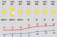
With predictions marking the transition to sunnier days from March 17 to March 23, local forecasters expect warm temperatures over the next week, noting overall comfortable conditions as daytime highs approach the 20°C mark from March 20 onward. It is prudent to note the sizable temperature differences, signaling frost risks particularly for agricultural outputs.
Health advisories state flu conditions will be prevalent, urging caution as heavy winds alongside changing temperatures may facilitate the spread of respiratory illnesses. Residents are encouraged to observe changes and adhere to recommended clothing adjustments and maintain safety practices, especially around fire risks as summer nears.
The forthcoming weather pattern delivers consistent warmth and sun across the eastern regions, whilst recalibrations will be needed to face the unpredictable conditions starting later this week.