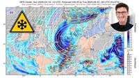
A significant sudden stratospheric warming event, currently taking place over the Arctic, could lead to extreme weather conditions including frost and snow across Europe, particularly Germany, within the next couple of weeks. Meteorologists have flagged this rare phenomenon as capable of sending icy polar air southward, which may result in late winter conditions as early as the end of March 2025.
The sudden stratospheric warming (SSW), as defined by experts, is characterized by drastic temperature increases, typically upwards of 50 degrees Celsius within mere days. This intense warmth can disrupt the polar vortex, a major atmospheric feature consisting of strong west-to-east winds surrounding cold polar air. When this vortex weakens or even splits, it can allow cold Arctic air to spill southward, impacting weather significantly across Europe.
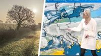
Dominik Jung, a meteorologist at wetter.net, explains, “A sudden stratospheric warming (SSW) is a rare but extremely strong weather phenomenon.” This SSW is currently showing potential effects for Germany, with various weather models predicting snowfall and temperatures plummeting to below normal as early as April 1, 2025.
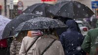
Beginning mid-March, regions across Germany have already begun facing extreme temperature fluctuations from initially sunny and mild temperatures, with highs around 20 degrees Celsius, to wet and cold conditions hovering between 5 to 10 degrees Celsius. Places like Baden-Württemberg and Rheinland-Pfalz have felt this shift, demonstrating symptoms of winter-like weather as conditions have rapidly deteriorated.
“The situation is highly exciting,” comments Jung. “A massive temperature spike in the stratosphere can radically upend weather patterns!” Several models indicate the potential for Germany to be hit with icy polar air by early April, bringing snow to lower altitudes.
This Arctic warming event poses questions about the reliability of weather forecasts. Although some models predict severe cold and snow, uncertainty remains about whether the frigid air will actually reach Germany, as similar air could drift toward the USA or Asia instead. A white April, it seems, is back on the table.
This meteorological phenomenon is not just confined to Germany's borders. Countries across the northern hemisphere are monitoring the SSW's effects, as it has the potential to alter global weather patterns significantly. For regions like Baden-Württemberg, this means activity levels for winter storms could increase, bringing rain, snow, and varying temperatures throughout the coming weeks.
Besides the immediate impacts of snow and freezing temperatures, there is concern among meteorologists about dangerous conditions such as black ice, particularly as temperatures approach freezing. Jung cautions, “It is quite plausible we will suddenly see snow showers and frosts – a harsh setback for spring.” On March 14, 2025, forecasts suggested highs between 6 to 7 degrees Celsius across several regions including Stuttgart and Mannheim. Temperatures on the following weekend dropped even lower, between 1 to 7 degrees Celsius, and prolonged cool temperatures were expected leading up to March 18.
The importance of monitoring the stratospheric dynamics cannot be overstated. According to meteorologists, the phenomenon could be the determining factor for whether Germany will experience yet another bout of harsh winter weather sooner rather than later. “We are certainly on the cusp of witnessing notable atmospheric changes,” Jung remarked, reflecting on the precarious path western Europe’s weather currently occupies.
Understanding this relationship between stratospheric behavior and tropospheric weather is also pivotal. Once the polar vortex begins weakening, it has the potential to send cold outbreaks even to more temperate regions. The next few days will be critically telling of how likely Germany will be to revert to winters of old. Will snow and ice make their way back to regions typically warming up for spring?
All things considered, these unpredictable weather shifts call attention not only to the immediate cold weather expected but also to the broader shifts occurring because of climate factors influencing our atmosphere. Whether weather patterns will lead to significant snowfalls across Germany remains uncertain, but one thing is clear: the excitement and trepidation surrounding the sudden stratospheric warming event are palpable, with meteorologists around the globe waiting to see how this weather drama will play out over the coming days.