As June 3, 2025, unfolds, weather patterns across the globe are showcasing a varied tableau of conditions, from the wet and windy United Kingdom to the stormy yet refreshing atmosphere in Delhi and the partly cloudy skies over Nepal. Each region faces its own meteorological narrative, shaped by local and broader climatic factors that dictate daily life and safety advisories.
In Nepal, the Meteorological Forecasting Division reports a day marked by partly to generally cloudy skies throughout the country. The afternoon promises light to moderate rain accompanied by thunder and lightning in several hilly areas, notably within the Koshi, Sudurpaschim, Gandaki, and Karnali provinces. This precipitation is not confined to these regions alone; one or two places in other parts of the country may also experience similar weather. Particularly in the high-hill and mountainous zones of Koshi and Sudurpaschim, light rainfall or snowfall is anticipated, with a chance of such conditions elsewhere as well.
The night in Nepal continues this pattern, with light to moderate rain and thunder expected in a few locations in Koshi Province and sporadically across Madhesh, Bagmati, Gandaki, and other hilly regions. Additionally, some high-hill and mountainous areas might witness light rain or snowfall during the late hours. This blend of rain and snow in elevated areas underscores the complex climatic interplay at work in Nepal’s diverse topography.
Meanwhile, Delhi greeted its residents with a cooler, more pleasant morning on this Tuesday. The skies remained cloudy, offering a welcome break from the usual heat and humidity. Light winds contributed to the comfortable atmosphere, as the India Meteorological Department (IMD) issued a yellow alert signaling more rain, thunderstorms, and lightning across parts of the city. Residents were advised to prepare for gusty winds reaching speeds of 40 to 50 kilometers per hour, with temporary gusts potentially hitting up to 60 kmph. The forecast also included a warning of stormy weather conditions during the day.
Looking ahead, the IMD projects a stabilization of weather from June 5 onwards, with partly cloudy skies and a gradual rise in temperatures. Daytime highs are expected to climb to between 38 and 40 degrees Celsius by early next week, while nighttime lows will increase to a range of 26 to 28 degrees Celsius. Importantly, despite this warming trend, the IMD has clarified that no heatwave conditions are forecast for the coming seven days. Winds are also expected to shift to a north-westerly direction later in the week, bringing moderate breezes of 20 to 30 kmph.
The recent rain in Delhi and the surrounding National Capital Region (NCR) has had a beneficial effect on air quality. According to the Central Pollution Control Board (CPCB), the Air Quality Index (AQI) improved to the 'moderate' category on the morning of June 3, dropping to 138 at 8 a.m. from 166 the previous day at the same time. This improvement is attributed to the cleansing effect of widespread rainfall, which helped clear pollutants from the atmosphere. Other NCR locations reflected similar improvements, with Gurugram at an AQI of 138, Noida at 144, Greater Noida at 104, and Ghaziabad at 109. The CPCB categorizes AQI values from 0 to 50 as 'good,' 51 to 100 as 'satisfactory,' 101 to 200 as 'moderate,' 201 to 300 as 'poor,' 301 to 400 as 'very poor,' and 401 to 500 as 'severe.'
The meteorological factors behind Delhi’s recent rain spell are complex. The IMD attributes it to the interplay of a Western Disturbance characterized by a cyclonic circulation over northern Pakistan at mid-tropospheric levels, a separate cyclonic circulation over Haryana at lower levels, and a continuous inflow of moisture from the Arabian Sea. These dynamic and thermodynamic elements combined to foster the development of the storms and precipitation observed.
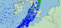
Across the United Kingdom, the Met Office paints a contrasting picture. Following a brief period of sunshine, June 3 is set to be a wet and windy day over much of England, Wales, and Scotland. Clouds and rain are expected to gradually cover England and Wales, with the southeast likely to see these conditions clear by late afternoon. Elsewhere, sunny spells will intermingle with blustery showers, especially in northern areas.
Wind will be particularly strong in the north, with coastal gales forecast for northern Scotland. Temperatures will dip below recent highs, offering a cooler day overall. As night falls, blustery showers will persist in northern parts of the UK, while the south is expected to enjoy drier conditions and clear skies. Winds should ease overnight, and temperatures will drop further, with the possibility of patchy grass frost in northern and western regions.
These diverse weather experiences—from Nepal’s mix of rain and snow in mountainous areas, Delhi’s stormy but cleansing rains, to the UK’s wet and windy conditions—highlight the intricate and region-specific nature of meteorology. They also underscore the importance of staying informed and prepared, whether it’s by heeding safety advisories in Delhi or bracing for coastal gales in Scotland.
As the world moves through early June, these weather patterns remind us of nature’s complexity and the ever-changing atmospheric dynamics that shape our daily lives. Whether it’s the refreshing rains that improve air quality in Delhi or the cooler, gusty winds buffeting the UK, each forecast carries implications for residents’ comfort, safety, and routines.