Spain is bracing for a significant weather change as the newly named storm, Nuria, is set to bring heavy rains and strong winds across the country starting Wednesday, April 2, 2025. This storm, the 14th high-impact storm of the season, has already begun to make its presence felt with initial rains reported in parts of Extremadura and Andalusia.
According to the State Meteorological Agency (Aemet), Nuria is the fifth named storm in less than a month, following Jana, Konrad, Laurence, and Martinho. The storm will particularly impact the Iberian Peninsula beginning Thursday night, especially in the western regions, with forecasts indicating strong winds and significant rainfall.
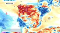
As of Tuesday, April 1, 2025, temperatures across Spain have risen slightly, but this mild weather is expected to give way to instability as the storm approaches. Aemet spokesperson Rubén del Campo noted that while nighttime temperatures are on the rise, daytime highs in southern regions will drop due to increasing cloud cover.
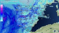
On Wednesday, the weather will shift dramatically, with rain and showers expected to spread across nearly all territories. The storm will particularly affect regions like Aragon, Catalonia, and the Valencian Community from early morning, with heavier rains anticipated in the Central System and southern Galicia.
“From midday Wednesday, the Atlantic storm will begin to leave rainfall across much of the territory, with the most intense precipitation expected in the vicinity of the Central System and in southern Galicia,” del Campo explained.
Temperatures are projected to drop significantly, with some areas experiencing a decline of over 10 degrees Celsius compared to the previous day. For instance, Teruel, which may reach around 24 degrees on Tuesday, is expected to plummet to a maximum of only 11 degrees on Wednesday.
The storm will also bring snow to the Pyrenees, with levels expected to be around 2,200 meters. Yellow warnings have been issued for wind in Aragón, rough seas in Galicia, and wind in Navarra.
Thursday and Friday will see continued rainfall across most of the Peninsula due to Nuria, although regions like northern Aragón, Catalonia, the southeast, and the Balearic Islands may remain somewhat sheltered from the worst of the weather. The heaviest rains are forecasted for the Central System and western Andalusia, with accumulations potentially reaching 60 liters per square meter in some areas.
The storm’s impact will extend to the Canary Islands, where heavy rainfall is expected, particularly in La Palma, Tenerife, and Gran Canaria, with forecasts indicating over 20-40 liters per square meter. The Aemet has already issued orange-level warnings for wind and coastal phenomena in these regions.
As the week progresses, the weather is anticipated to stabilize after Nuria passes, but forecasters caution that additional Atlantic storms may follow. The weeks of April 7 to April 13 and April 14 to April 20 are predicted to be rainier than normal, suggesting that the wet weather pattern may persist.
In summary, Spain is preparing for a dramatic shift in weather as storm Nuria approaches, promising to bring heavy rains, strong winds, and significant temperature drops. Citizens are advised to stay updated on weather forecasts and prepare for potentially hazardous conditions, especially in the affected regions.


